History in Structure

Service Building to E of Ty-du Farmhouse

A Grade II Listed Building in Ceiriog Ucha, Wrexham

More Photos »
Approximate Location Map
Large Map »

Coordinates

Latitude: 52.8976 / 52°53'51"N

Longitude: -3.2135 / 3°12'48"W

OS Eastings: 318462

OS Northings: 334044

OS Grid: SJ184340

Mapcode National: GBR 6W.PKX1

Mapcode Global: WH78H.LFYG

Plus Code: 9C4RVQXP+3H

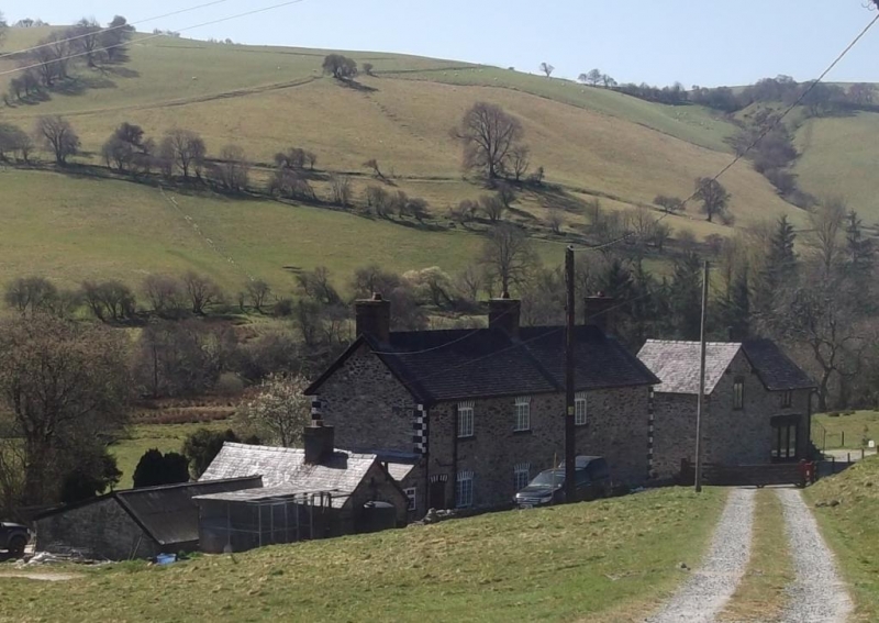
Entry Name: Service Building to E of Ty-du Farmhouse

Listing Date: 23 May 2003

Last Amended: 23 May 2003

Grade: II

Source: Cadw

Source ID: 81164

Building Class: Domestic

ID on this website: 300081164

Location: Located immediately to the E of, and aligned with the farmhouse.

County: Wrexham

Community: Ceiriog Ucha

Community: Ceiriog Ucha

Locality: Pont Ricket

Traditional County: Denbighshire

Tagged with: House

Find accommodation in
Llanarmon Dyffryn-Ceiriog

History

Probably late C19 and contemporary with the remodelling of the farmhouse. A small service range, probably including a bakehouse and washroom.

Exterior

Late C19 service range, probably bakehouse or washroom. Small single-storey range facing W, of rubble stone with slate roof and brick ridge stack to L of centre. The front includes 2 planked doors; rear wing with altered roof-line covered by corrugated iron sheeting, possibly an earlier structure.

Interior

No access to interior at time of inspection.

Reasons for Listing

Listed for group value with Ty-du Farmhouse and cart-shed and granary to W.

External Links

External links are from the relevant listing authority and, where applicable, Wikidata. Wikidata IDs may be related buildings as well as this specific building. If you want to add or update a link, you will need to do so by editing the Wikidata entry.

Recommended Books

Other nearby listed buildings

  • II Ty-du
    Set down from the B4500 and reached by a short track, approx 0.7km E of Tregeiriog. Flanked by late C19 outbuildings in the same style.
  • II Cart-shed and granary to W of Ty-du Farmhouse
    Located immediately to the W of, and aligned with the farmhouse.
  • II Pontricket Farmhouse
    Reached by a short driveway. The farmhouse is built on the slope, with uphill N gable-end towards the road and entrance facing E.
  • II Pont Ricket
    The bridge carries a narrow lane which runs S from the B4500 over the River Ceiriog. It is approx 150m from the main road.
  • II Hendre
    Located at the end of a short track which runs NE from Pont Ricket.
  • II Farm Building to SE of Hendre Farmhouse
    Located across the farmyard and to the SE of the farmhouse.
  • II Small Barn at Hendre
    Up-slope and E of the house at Hendre, facing the Large Barn across a small yard.
  • II Pont y Felin
    Located 300m S of the main crossroads in Tregeiriog, and carrying the lane to Rhiwlas over the River Ceiriog.

BritishListedBuildings.co.uk is an independent online resource and is not associated with any government department. All government data published here is used under licence. Please do not contact BritishListedBuildings.co.uk for any queries related to any individual listed building, planning permission related to listed buildings or the listing process itself.

British Listed Buildings is a Good Stuff website.