Latitude: 51.7294 / 51°43'45"N
Longitude: -3.3853 / 3°23'7"W
OS Eastings: 304422
OS Northings: 204312
OS Grid: SO044043
Mapcode National: GBR HN.295S
Mapcode Global: VH6CY.8SPN
Plus Code: 9C3RPJH7+PV
Entry Name: Base of Chimney at Cwm Pit
Listing Date: 29 July 2003
Last Amended: 29 July 2003
Grade: II
Source: Cadw
Source ID: 81752
Building Class: Industrial
ID on this website: 300081752
Location: In forestry on the W side of the Taf valley reached by a track some 1km NW from the Gethin Forest picnic site.
County: Merthyr Tydfil
Community: Troed-y-rhiw
Community: Troed-y-Rhiw
Locality: Blaen Canaid
Built-Up Area: Merthyr Tydfil
Traditional County: Glamorgan
Tagged with: Architectural structure
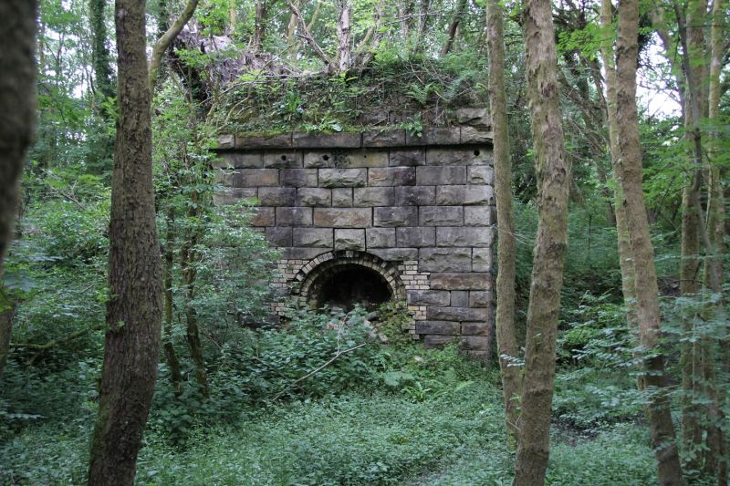
Chimney base of colliery chimney of the Cwm Pit colliery, a complex now overgrown in woodland but still with surviving massive stone revetment walls to stream and arched entries into the levels. Cwm Pit was sunk between 1820 and 1840, the boom years of the deep pits in the area such as Collier's Row, Glyndyrys and Rhyd-y-car. The chimney stands on a rise to the S of the main remains. Old photographs show a very tall square stack standing S of a 3-storey engine house on the revetment wall, a hipped building SW of the chimney and various buildings to W.
Chimney base built of exceptionally large rock-faced stone squared blocks rising to heavy similar raised band and then stepped back in three steps of similar blocks to site of demolished shaft. Each side has a large arched stoking hole, three lined with yellow brick but perhaps originally all of masonry as one survives with cut stone voussoirs and no yellow brick.
Included as a particularly massively built chimney base, an historically important feature of this earlier C19 pit.
External links are from the relevant listing authority and, where applicable, Wikidata. Wikidata IDs may be related buildings as well as this specific building. If you want to add or update a link, you will need to do so by editing the Wikidata entry.


Other nearby listed buildings