Approximate Location Map
Large Map »
Latitude: 51.6653 / 51°39'54"N
Longitude: -3.8092 / 3°48'33"W
OS Eastings: 274972
OS Northings: 197827
OS Grid: SS749978
Mapcode National: GBR H2.6BL3
Mapcode Global: VH4K5.XDLR
Plus Code: 9C3RM58R+48
Entry Name: Neath River Bridge (partly in Neath community)
Listing Date: 5 October 1992
Last Amended: 26 November 2003
Grade: II
Source: Cadw
Source ID: 82090
Building Class: Transport
ID on this website: 300082090
Location: Spanning the River Neath and adjoining the road bridge over the Tennant Canal. Reached from Bridge St, Neath on the E side and from a modern footbridge on the W side, beginning beside the A474 and cr
County: Neath Port Talbot
Town: Neath
Community: Blaenhonddan
Community: Blaenhonddan
Locality: Neath
Built-Up Area: Neath
Traditional County: Glamorgan
Tagged with: Bridge
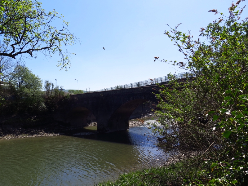
Road bridge, erected in 1790s to replace an earlier bridge at this historic river crossing. A timber bridge was recorded near here by John Leland in the C16, a later bridge being of timber and stone. The bridge was designed by David Edwards son of the famous bridge builder Rev William Edwards of Pontypridd and built by direct labour under the surveyor Thomas Edwards. The bridge was formerly ramped but about 1850 the NW end was raised to accommodate the building of the Low Level railway. The original line can be seen in the masonry of the bridge and the adjoining bridge over the Tennant canal. Footpaths on cantilevers were added in 1869 by the contractor William Jones of Westernmoor enabling the full 6.5m width of the original bridge to be used by vehicles. The bridge was closed to traffic in the later C20 when the A465 dual-carriageway was built and a raised footbridge constructed on it to connect Cadoxton Road with the Neath side of the river.
Road bridge, well-finished coursed rubble stone with dressed stone voussoirs to three almost semicircular arches. Outer arches are nearly 11m wide and the centre one over 15m wide with pointed cutwaters to both sides. Later parapets with cement block coping and C20 deck, walled on NW end, now carrying a raised footbridge.
Listed for the special interest of the late C18 bridge which is well preserved beneath the modern alterations. Group value with the adjoining bridge over Tennant Canal.
External links are from the relevant listing authority and, where applicable, Wikidata. Wikidata IDs may be related buildings as well as this specific building. If you want to add or update a link, you will need to do so by editing the Wikidata entry.


Other nearby listed buildings
