Approximate Location Map
Large Map »
Latitude: 52.9584 / 52°57'30"N
Longitude: -3.4057 / 3°24'20"W
OS Eastings: 305665
OS Northings: 341034
OS Grid: SJ056410
Mapcode National: GBR 6N.KM5Y
Mapcode Global: WH780.NWFY
Plus Code: 9C4RXH5V+8P
Entry Name: Pont Cynwyd
Listing Date: 28 January 2004
Last Amended: 28 January 2004
Grade: II
Source: Cadw
Source ID: 82410
ID on this website: 300082410
Location: The bridge carries the B4401 N-S through Cynwyd village.
County: Denbighshire
Community: Cynwyd
Community: Cynwyd
Built-Up Area: Cynwyd
Traditional County: Merionethshire
Tagged with: Bridge Road bridge
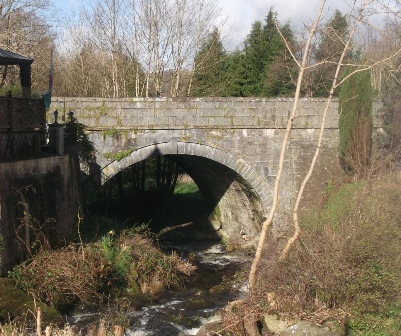
Monumental bridge, probably late C19 and shown on the Ordnance Survey of 1891. A tablet, which appears to be inserted, commemorates the coronation of Edward VII.
Long causeway and bridge which raises the road over the River Trystion. The battered side walls are constructed of snecked freestone with pecked surface; string course; coursed freestone parapets, the flat coping stones with slightly chamfered angles.
Single-span bridge offset towards S with high round arch of stone voussoirs with dripmould; this section of the bridge is not battered. To its N is a narrow round-arched opening of stone voussoirs which carries a footpath under the structure. The interior of the passage has rubble side walls and flat stone slabs to the roof. Immediately to its N is a low flat-headed opening which carried a mill-race. The bridge has a flat deck, the inner side of the E parapet bearing a marble tablet commemorating the coronation of King Edward VII and Queen Alexandra, August 9th 1902 erected by the parishioners of Llangar.
Listed as a fine monumental bridge and causeway in a village setting which retains late C19 character.
External links are from the relevant listing authority and, where applicable, Wikidata. Wikidata IDs may be related buildings as well as this specific building. If you want to add or update a link, you will need to do so by editing the Wikidata entry.


Other nearby listed buildings
