History in Structure

Milepost to N of Talsarnau

A Grade II Listed Building in Talsarnau, Gwynedd

More Photos »
Approximate Location Map
Large Map »

Coordinates

Latitude: 52.9094 / 52°54'33"N

Longitude: -4.0551 / 4°3'18"W

OS Eastings: 261893

OS Northings: 336636

OS Grid: SH618366

Mapcode National: GBR 5S.NRG4

Mapcode Global: WH55T.P46G

Plus Code: 9C4QWW5V+PX

Entry Name: Milepost to N of Talsarnau

Listing Date: 30 December 2004

Last Amended: 30 December 2004

Grade: II

Source: Cadw

Source ID: 83458

Building Class: Transport

ID on this website: 300083458

Location: Set alongside the NW side of the A496 leading N out of the village of Talsarnau, opposite the entrance to Tregwylan Hotel.

County: Gwynedd

Community: Talsarnau

Community: Talsarnau

Traditional County: Merionethshire

Tagged with: Milestone

Find accommodation in
Talsarnau

History

Probably mid C19 milepost. Merionydd was the last of the Welsh counties to have turnpike roads and it was at a county meeting in Dolgellau in 1775 that it was resolved to convert the principal tracks of the county into turnpikes, in partnership with Caernarfonshire. By the end of the C18 most of the existing roads had been brought under the Trust under the Merionydd Turnpike Act of 1777. The stretch of road that this series of mileposts serves was constructed following the reclamation of Traeth Mawr, and the erection of the Cob at Porthmadog, opened in 1808.

Exterior

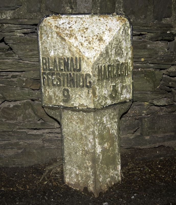
Cast iron milepost with a triangular profile, wider at the top with a raking head and facing panels which bear the names and distances: BLAENAU / FFESTINIOG / 9 on the left hand face and HARLECH / 5 on the right.

Reasons for Listing

Listed as a C19 milepost, one of a series along the road between Maentwrog and Harlech.

External Links

External links are from the relevant listing authority and, where applicable, Wikidata. Wikidata IDs may be related buildings as well as this specific building. If you want to add or update a link, you will need to do so by editing the Wikidata entry.

Recommended Books

Other nearby listed buildings

  • II Glanllyn Cottage
    Set back slightly from the S and E sides of the country road which leads N from Eisingrug to the Church of St Tecwyn, at the junction with the road down to the village of Llandecwyn at Bryn Bwbach.
  • II Glanrafon
    Set well back from the E side of the country road leading N from Eisingrug to the Church of St Tecwyn.
  • II Pont Dolorgan
    Carrying the country road which leads N from Eisingrug to the Church of St Tecwyn and spanning the Afon y Glyn
  • II Capel Soar
    Located to N side of a narrow country road which leads through the small hamlet of Soar.
  • II Milepost to N of Llandecwyn
    Set along the NW side of the A496 leading N out of the village of Llandecwyn.
  • II Field barn at Plas Llandecwyn
    Along the W side of the country lane, once the country road to Maentwrog, which leads to the Church of St Tecwyn; opposite the entrance to Plas Llandecwyn.
  • II Cottage at Plas Llandecwyn
    Set back from the E side of the country lane, once the country road to Maentwrog, which leads to the Church of St Tecwyn. The building lies to the S of the house and barn at Plas Llandecwyn.
  • II Lofted stable and cartshed at Plas Llandecwyn
    Set back from the E side of the country lane, once the country road to Maentwrog, which leads to the Church of St Tecwyn. The range lies to the W of the house.

BritishListedBuildings.co.uk is an independent online resource and is not associated with any government department. All government data published here is used under licence. Please do not contact BritishListedBuildings.co.uk for any queries related to any individual listed building, planning permission related to listed buildings or the listing process itself.

British Listed Buildings is a Good Stuff website.