History in Structure

Tollgate Cottage aka Cerdwyd

A Grade II Listed Building in Maentwrog, Gwynedd

More Photos »
Approximate Location Map
Large Map »

Coordinates

Latitude: 52.9472 / 52°56'49"N

Longitude: -3.9883 / 3°59'17"W

OS Eastings: 266503

OS Northings: 340718

OS Grid: SH665407

Mapcode National: GBR 5W.L9NQ

Mapcode Global: WH55N.Q50Y

Plus Code: 9C4RW2W6+VM

Entry Name: Tollgate Cottage aka Cerdwyd

Listing Date: 25 February 2005

Last Amended: 25 February 2005

Grade: II

Source: Cadw

Source ID: 83966

Building Class: Domestic

Also known as: Cerdwyd

ID on this website: 300083966

Location: Located at the E side of the A496 at the N end of the village of Maentwrog; directly SE of Pont Maentwrog.

County: Gwynedd

Community: Maentwrog

Community: Maentwrog

Traditional County: Merionethshire

Tagged with: Cottage

Find accommodation in
Maentwrog

History

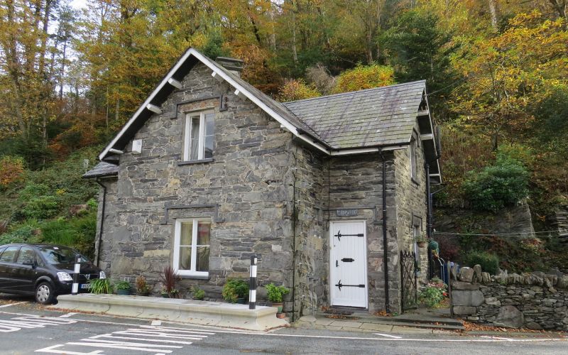
Late C19 cottage. Shown as toll cottage on 1st edition O.S. map, and built by the Tan y bwlch estate as part of an extensive programme of rebuilding and improvement in the late C19.
Offered up for sale in the auction of the Plas Tan-y-bwlch estate, 1910, in Lot 12 'The Picturesque Rural Village of Maentwrog'. The property was described as The Old Tollgate, occupied by Richard Pugh, for an annual rent of £6-0s-0d (£6.00).

Exterior

House, in the simplified gothic style characteristic of the later C19 work by the Tan-y-bwlch estate. Rubble built, slate roof with eaves projecting on brackets, central stack with diagonal shaft. One and a half storeys, T-shaped plan with advanced central gable. This has a 2-light casement window on each floor. Doorways in flanking bays, and casement windows in gable ends. All openings have drop-ended hood-moulds.

Interior

The interior was not inspected at the time of the survey (June/July 2003).

Reasons for Listing

Listed as a late C19 tollgate cottage retaining original character as an estate cottage and forming a group with the adjacent road bridge and milestone at the N end of the estate village of Maentwrog.

External Links

External links are from the relevant listing authority and, where applicable, Wikidata. Wikidata IDs may be related buildings as well as this specific building. If you want to add or update a link, you will need to do so by editing the Wikidata entry.

Recommended Books

Other nearby listed buildings

  • II Milestone at Pont Maentwrog
    Set in the walling branching to SE off Pont Maentwrog. (A496)
  • II Pont Maentwrog
    Roadbridge spanning the Afon Dwyryd, linking the A487(T) and the A496 to N of the village of Maentwrog.
  • II The Old Rectory
    Set along the W side of Bull Street (A496) at the N end of the village of Maentwrog; located to NE of the Church of St. Twrog.
  • II Stable block to S of The Old Rectory
    Set along the W side of Bull Street (A496) at the N end of the village of Maentwrog; to N of The Grapes Hotel and S of The Old Rectory.
  • II Stable block to N of The Grapes Hotel
    Set along the W side of Bull Street (A496) at the N end of the village of Maentwrog; located to N of the Grapes Hotel.
  • II The Grapes Hotel
    Set alongside the W side of Bull Street (A496) towards the N end of the village of Maentwrog; located NE of the Church of St. Twrog.
  • II Bwlch y Maen - Former Co-operative shop
    Set along the W side of Bull Street (A496) at the N end of the village of Maentwrog; in alignment and directly S of The Grapes Hotel.
  • II Tan-lan
    Set along the E side of Bull Street (A496) at the N end of the village of Maentwrog; opposite The Grapes Hotel.

BritishListedBuildings.co.uk is an independent online resource and is not associated with any government department. All government data published here is used under licence. Please do not contact BritishListedBuildings.co.uk for any queries related to any individual listed building, planning permission related to listed buildings or the listing process itself.

British Listed Buildings is a Good Stuff website.