History in Structure

Milestone at Pont Maentwrog

A Grade II Listed Building in Maentwrog, Gwynedd

More Photos »
Approximate Location Map
Large Map »

Coordinates

Latitude: 52.9474 / 52°56'50"N

Longitude: -3.9883 / 3°59'17"W

OS Eastings: 266503

OS Northings: 340735

OS Grid: SH665407

Mapcode National: GBR 5W.L9NN

Mapcode Global: WH55N.Q50T

Plus Code: 9C4RW2W6+WM

Entry Name: Milestone at Pont Maentwrog

Listing Date: 25 February 2005

Last Amended: 25 February 2005

Grade: II

Source: Cadw

Source ID: 84011

Building Class: Transport

ID on this website: 300084011

Location: Set in the walling branching to SE off Pont Maentwrog. (A496)

County: Gwynedd

Community: Maentwrog

Community: Maentwrog

Traditional County: Merionethshire

Tagged with: Milestone

Find accommodation in
Maentwrog

History

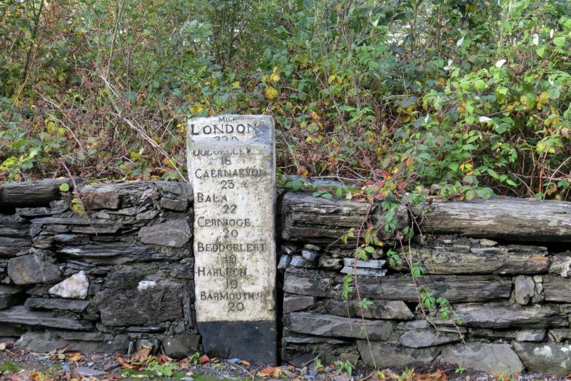
Probably late C18 milepost. Merioneth was the last of the Welsh counties to have turnpike roads and it was at a county meeting in Dolgellau in 1775 that it was resolved to convert the principal tracks of the county into turnpikes, in partnership with Caernarfonshire. By the end of the C18 most of the existing roads had been brought under the Trust under the Merioneth Turnpike Act of 1777.

Exterior

Stone slab milestone, roughly rectangular in shape and now painted, that bears the inscription:
(20miles = 32 Km)
MILES / LONDON / 220 / DOLGELLEY / 18 / CAERNARVON / 23 / BALA / 22 / CERNIOGE / 20 / BEDDGELERT / 10 / HARLECH / 10 / BARMOUTH / 20.

Reasons for Listing

Listed as a well preserved late C18 milestone that forms a group with the adjacent road bridge and tollgate cottage at the N end of the village of Maentwrog.

External Links

External links are from the relevant listing authority and, where applicable, Wikidata. Wikidata IDs may be related buildings as well as this specific building. If you want to add or update a link, you will need to do so by editing the Wikidata entry.

Recommended Books

Other nearby listed buildings

  • II Tollgate Cottage aka Cerdwyd
    Located at the E side of the A496 at the N end of the village of Maentwrog; directly SE of Pont Maentwrog.
  • II Pont Maentwrog
    Roadbridge spanning the Afon Dwyryd, linking the A487(T) and the A496 to N of the village of Maentwrog.
  • II The Old Rectory
    Set along the W side of Bull Street (A496) at the N end of the village of Maentwrog; located to NE of the Church of St. Twrog.
  • II Stable block to S of The Old Rectory
    Set along the W side of Bull Street (A496) at the N end of the village of Maentwrog; to N of The Grapes Hotel and S of The Old Rectory.
  • II Stable block to N of The Grapes Hotel
    Set along the W side of Bull Street (A496) at the N end of the village of Maentwrog; located to N of the Grapes Hotel.
  • II The Grapes Hotel
    Set alongside the W side of Bull Street (A496) towards the N end of the village of Maentwrog; located NE of the Church of St. Twrog.
  • II Bwlch y Maen - Former Co-operative shop
    Set along the W side of Bull Street (A496) at the N end of the village of Maentwrog; in alignment and directly S of The Grapes Hotel.
  • II Tan-lan
    Set along the E side of Bull Street (A496) at the N end of the village of Maentwrog; opposite The Grapes Hotel.

BritishListedBuildings.co.uk is an independent online resource and is not associated with any government department. All government data published here is used under licence. Please do not contact BritishListedBuildings.co.uk for any queries related to any individual listed building, planning permission related to listed buildings or the listing process itself.

British Listed Buildings is a Good Stuff website.