History in Structure

Coach house range at the Oakeley Arms

A Grade II Listed Building in Maentwrog, Gwynedd

More Photos »
Approximate Location Map
Large Map »

Coordinates

Latitude: 52.9495 / 52°56'58"N

Longitude: -3.9953 / 3°59'43"W

OS Eastings: 266039

OS Northings: 340989

OS Grid: SH660409

Mapcode National: GBR 5W.L7YR

Mapcode Global: WH55N.L4P5

Plus Code: 9C4RW2X3+RV

Entry Name: Coach house range at the Oakeley Arms

Listing Date: 25 February 2005

Last Amended: 25 February 2005

Grade: II

Source: Cadw

Source ID: 83994

Building Class: Domestic

ID on this website: 300083994

Location: Set at the N side of the A487(T) at its junction with the B4410, to NE end of the small hamlet of Tan-y-bwlch. The coach house range is directly N of the Oakeley Arms.

County: Gwynedd

Community: Maentwrog

Community: Maentwrog

Locality: Tan-y-bwlch

Traditional County: Merionethshire

Tagged with: Carriage house

Find accommodation in
Maentwrog

History

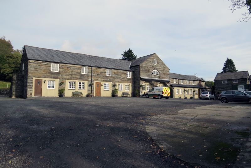
Probably early C19 lofted coach house range, contemporary with the refacing of the adjacent public house and hotel building.

Exterior

Lofted linear range, slightly advanced at R (SE) end. Built of coursed local stone with massive stones as lintels; slate roof. The main range has 4 wide bays (now with boarded doors), each of which has a 2 light timber casement window above; the windows are to the R end of each bay and set under the eaves. At the far R (SE) end of the range is a higher gabled range with wide coach bay at ground floor level and circular window set in the gable apex above.

Interior

The interior was not inspected at the time of the survey (June/July 2003).

Reasons for Listing

Included as a little altered early C19 coach house range that is a significant part of the complex at this major inn.

External Links

External links are from the relevant listing authority and, where applicable, Wikidata. Wikidata IDs may be related buildings as well as this specific building. If you want to add or update a link, you will need to do so by editing the Wikidata entry.

Recommended Books

Other nearby listed buildings

  • II The Oakeley Arms Hotel
    Set at the N side of the A487(T) at its junction with the B4410, to NE end of the small hamlet of Tan-y-bwlch.
  • II Milestone at the Oakeley Arms
    Set at the N side of the A487(T) at its junction with the B4410, to NE end of the small hamlet of Tan-y-bwlch. The milestone is set in a wall at the S corner of the Oakeley Arms.
  • II Former kiln house at Tan-y-bwlch mill
    Set alongside the NW side of the A487(T) in the centre of the small hamlet of Tan-y-bwlch. Directly to NE of the former mill and mill house.
  • II Ty'r Felin
    Set alongside the NW side of the A487(T) in the centre of the small hamlet of Tan-y-bwlch.
  • II Folly at Tan-y-Bwlch
    In an isolated location, set well back from the S side of the A487(T) and on the flood plain of the Afon Dwyryd. Lies to S of the Oakeley Arms.
  • II The White Barn
    In a slightly elevated position, set back from the SE side of the A487(T) in the centre of the small hamlet of Tan-y-bwlch.
  • II Hay Barn adjacent to Yr Hen Ysgubor and Crochendy Twrog
    On S side of A487, about 250m SW of junction with B 4410, aligned with road, attached to E of Yr Hen Ysgubor.
  • II Yr Hen Ysgubor aka Barton Lodge
    On S side of A487, about 250m SW of junction with B 4410, aligned with road, but at a lower level.

BritishListedBuildings.co.uk is an independent online resource and is not associated with any government department. All government data published here is used under licence. Please do not contact BritishListedBuildings.co.uk for any queries related to any individual listed building, planning permission related to listed buildings or the listing process itself.

British Listed Buildings is a Good Stuff website.