History in Structure

Gatepiers, Gates and Railings of Wesleyan Methodist Chapel

A Grade II Listed Building in Monmouth, Monmouthshire

More Photos »
Approximate Location Map
Large Map »

Coordinates

Latitude: 51.8125 / 51°48'45"N

Longitude: -2.7114 / 2°42'41"W

OS Eastings: 351050

OS Northings: 212895

OS Grid: SO510128

Mapcode National: GBR FL.WVDW

Mapcode Global: VH86T.YPFW

Plus Code: 9C3VR77Q+2C

Entry Name: Gatepiers, Gates and Railings of Wesleyan Methodist Chapel

Listing Date: 10 August 2005

Last Amended: 10 August 2005

Grade: II

Source: Cadw

Source ID: 85200

Building Class: Religious, Ritual and Funerary

ID on this website: 300085200

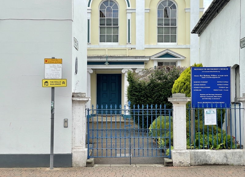
Location: Prominently sited within the linear group of historic buildings leading to St. James's Square on the east side of Monmouth and about 300m east of the town centre. The railings follow the street line

County: Monmouthshire

Town: Monmouth

Community: Monmouth (Trefynwy)

Community: Monmouth

Built-Up Area: Monmouth

Traditional County: Monmouthshire

Tagged with: Gate

Find accommodation in
Monmouth

History

Probably 1837 and contemporary with the chapel (qv) which is set back behind them.

Exterior

Rendered and painted brick with cast iron railings and gates. Three square piers with panelled faces, projecting cornices and square caps. Panel of spear head railings on dwarf wall to right. Double gates with spear finials to left.

Reasons for Listing

Included for its group value with the chapel and all the other historic buildings in St. James' Street.

External Links

External links are from the relevant listing authority and, where applicable, Wikidata. Wikidata IDs may be related buildings as well as this specific building. If you want to add or update a link, you will need to do so by editing the Wikidata entry.

Recommended Books

Other nearby listed buildings

  • II The Hame
    Prominently sited within the linear group of historic buildings leading to St. James's Square on the east side of Monmouth and about 300m east of the town centre.
  • II NO.16 St.james Street, Gwent
    Prominently sited within the linear group of historic buildings leading to St. James's Square on the east side of Monmouth and about 300m east of the town centre.
  • II NO.18 St.james Street (Borough Offices), Gwent
    Prominently sited within the linear group of historic buildings leading to St. James's Square on the east side of Monmouth and about 300m east of the town centre.
  • II Clent House
    Prominently sited within the linear group of historic buildings leading to St. James's Square on the east side of Monmouth and about 300m east of the town centre.
  • II NO.14 St.james Street, Gwent
    Prominently sited within the linear group of historic buildings leading to St. James's Square on the east side of Monmouth and about 300m east of the town centre.
  • II NO.7 St.james Street, Gwent
    Prominently sited within the linear group of historic buildings leading to St. James's Square on the east side of Monmouth and about 300m east of the town centre.
  • II NO.3 St.james Street (The Old Vicarage), Gwent
    Prominently sited within the linear group of historic buildings leading to St. James's Square on the east side of Monmouth and about 300m east of the town centre.
  • II NO.9 St.james Street, Gwent
    Prominently sited within the linear group of historic buildings leading to St. James's Square on the east side of Monmouth and about 300m east of the town centre.

BritishListedBuildings.co.uk is an independent online resource and is not associated with any government department. All government data published here is used under licence. Please do not contact BritishListedBuildings.co.uk for any queries related to any individual listed building, planning permission related to listed buildings or the listing process itself.

British Listed Buildings is a Good Stuff website.