Approximate Location Map
Large Map »
Latitude: 51.773 / 51°46'22"N
Longitude: -2.9411 / 2°56'27"W
OS Eastings: 335164
OS Northings: 208682
OS Grid: SO351086
Mapcode National: GBR F8.ZK2S
Mapcode Global: VH79F.ZP1N
Plus Code: 9C3VQ3F5+6H
Entry Name: Lower House Barn, with attached Cartshed and Granary, 400m to east of Panyt-y-goitre Farm
Listing Date: 9 December 2005
Last Amended: 9 December 2005
Grade: II
Source: Cadw
Source ID: 87131
Building Class: Agriculture and Subsistence
ID on this website: 300087131
Location: About 400m to east of Panyt-y-goitre crossroads at a bend in the road going towards the Church of St. Mary and the River Usk.
County: Monmouthshire
Town: Abergavenny
Community: Llanover (Llanofer)
Community: Llanover
Locality: Llanfair Kilgeddin
Traditional County: Monmouthshire
Tagged with: Granary
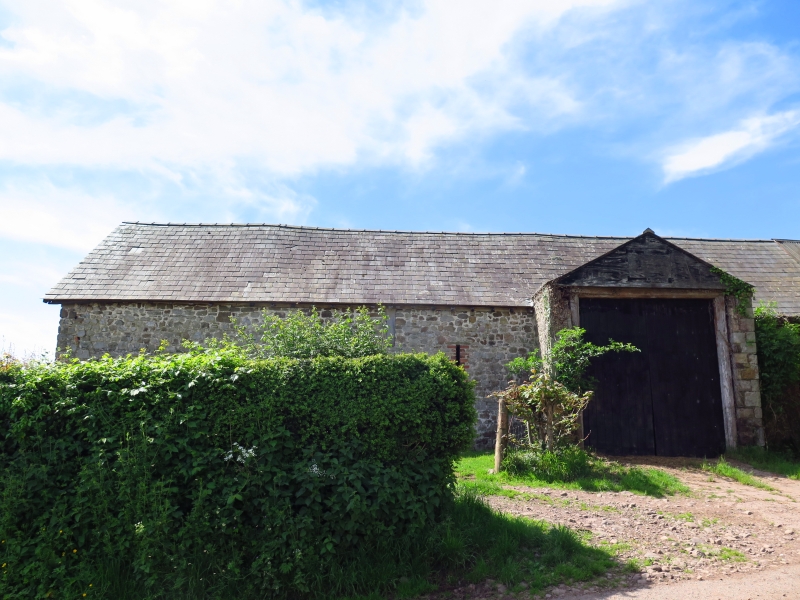
Probably C18 barn with the cartshed and granary added in the C19. No alteration since apart from the loss of the cartshed roof covering.
The barn is constructed of local sandstone rubble with some red brick dressings, natural slate roof. The attached cartshed and granary is red brick with a corrugated sheet metal roof. The cartshed was added to the barn's west gable end but is slightly canted.
The barn is rectangular with an off-centre entry, this is because there is a cowshed or stable with hayloft over at the west end; the gabled entry is central to the threshing barn. The stable has a small window, then comes a slit vent with brick dressing, then the roughly gabled cart entrance to the threshing floor, slit vent to right.
The cartshed, which is in English garden wall bond, is blind to the road. The right return gable has a taking-in door to the granary.
Rear elevation of the barn has another cart door. The cart shed is for two carts with a central post, and timber framed wall to granary above.
Interior not available at resurvey.
Included for its special interest as a probably C18 barn with the cartshed and granary added in the C19, a prominently sited, good example of regional type.
External links are from the relevant listing authority and, where applicable, Wikidata. Wikidata IDs may be related buildings as well as this specific building. If you want to add or update a link, you will need to do so by editing the Wikidata entry.


Other nearby listed buildings
