History in Structure

Milestone opposite Kilgetty Co-op

A Grade II Listed Building in Kilgetty, Pembrokeshire

More Photos »
Approximate Location Map
Large Map »

Coordinates

Latitude: 51.7321 / 51°43'55"N

Longitude: -4.7179 / 4°43'4"W

OS Eastings: 212412

OS Northings: 207209

OS Grid: SN124072

Mapcode National: GBR GD.N5HF

Mapcode Global: VH2PD.5QQJ

Plus Code: 9C3QP7JJ+VV

Entry Name: Milestone opposite Kilgetty Co-op

Listing Date: 15 March 2021

Grade: II

Source: Cadw

Source ID: 87800

ID on this website: 300087800

Location: Set into the hedge on the south side of Carmarthen Road, opposite Kilgetty co-op.

County: Pembrokeshire

Community: Kilgetty/Begelly (Cilgeti/Begeli)

Community: Kilgetty/Begelly

Locality: Kilgetty

Built-Up Area: Kilgetty

Traditional County: Pembrokeshire

History

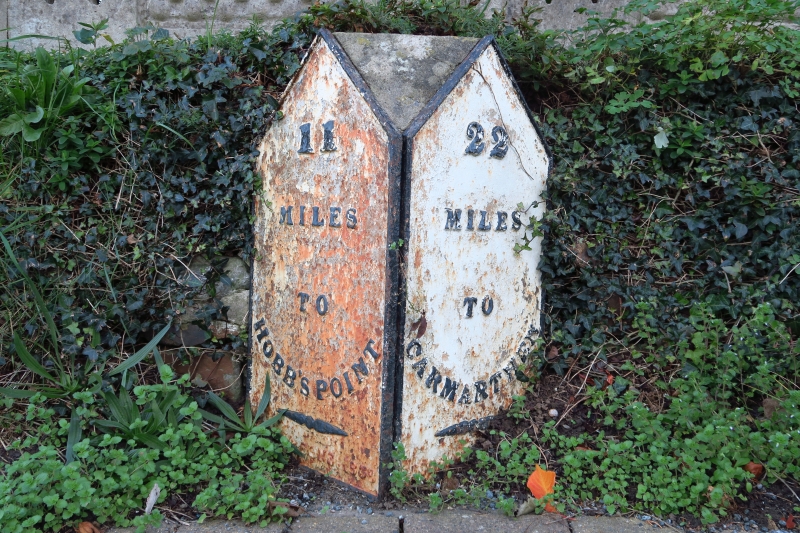
Milestone on the St Clears to Hobbs Point mail coach route, originally operated by the Tavernspite Trust. As a result of the Rebecca Riots the Turnpike Trusts were forced to consolidate within each County and form the "County Roads Board". It was probably after this consolidation that this milestone was erected (1836 - 40).

The plates were likely made by Moss & Sons, elsewhere dated 1838.

Exterior

Milestone, cast-iron plates on stone or concrete possibly replacing the original block, canted front with two triangular-headed faces. On left: 11 / miles / to / Hobbs Point’. On right : 22 / miles / to / Carmarthen’.

The plates are painted white with raised lettering in black and are butted together at 90 degrees, black trim, fixed to a solid backing.

Reasons for Listing

Included for historic transport interest, as part of the earlier C19 turnpike system.

External Links

External links are from the relevant listing authority and, where applicable, Wikidata. Wikidata IDs may be related buildings as well as this specific building. If you want to add or update a link, you will need to do so by editing the Wikidata entry.

Recommended Books

Other nearby listed buildings

  • II* Church of St. Mary
    In village of Begelly, 0.5 km N of the A477(T). The church is in a large churchyard with low stone wall, stile and lychgate to N.
  • II Milestone on A478 at King's Moor
    In the verge on the west side of the A478 at Kingsmoor, south of Begelly.
  • II Begelly House
    100 m NW of Begelly Church. Private grounds with a stone wall to the street including gatepiers with stone finial balls.
  • II Zion C. M. Chapel, Schoolroom and House, with Railings and Gate
    In the main street of the village of Begelly, on the E side. Small forecourt with stone piers, wrought iron railings and cast iron gate. Graveyard to the N and E. The chapel, school and house are in a
  • II Milestone on A478 outside Footlands Farm
    In the verge on the east side of the A478, against the wall outside Footlands Farm. North of Begelly.
  • II Tramway Bridge
    Over Ford's Lake in the village of Stepaside, to the SE of Brook Cottages. Ford's Lake is the Community boundary between Amroth and Kilgetty/Begelly.
  • II Tramway Bridge
    Over Ford's Lake in the village of Stepside, to the SE of Brook Cottages. Ford's Lake is the Community boundary between Amroth and Kilgetty/Begelly.
  • II Grove Colliery Cornish Beam Engine House
    100 m SW of Kilgetty Ironworks, on the W side of Pleasant Valley. The engine house is at the centre of a group of ruined colliery buildings, close to a quarry face at its rear.

BritishListedBuildings.co.uk is an independent online resource and is not associated with any government department. All government data published here is used under licence. Please do not contact BritishListedBuildings.co.uk for any queries related to any individual listed building, planning permission related to listed buildings or the listing process itself.

British Listed Buildings is a Good Stuff website.