Approximate Location Map
Large Map »
Latitude: 51.0666 / 51°3'59"N
Longitude: -1.7969 / 1°47'48"W
OS Eastings: 414329
OS Northings: 129719
OS Grid: SU143297
Mapcode National: GBR 51F.2JR
Mapcode Global: FRA 7639.KSN
Plus Code: 9C3W3683+M7
Entry Name: 24, the Close
Listing Date: 28 February 1952
Grade: II*
Source: Historic England
Source ID: 1023602
English Heritage Legacy ID: 318999
ID on this website: 101023602
Location: The Friary, Wiltshire, SP1
County: Wiltshire
Civil Parish: Salisbury
Built-Up Area: Salisbury
Traditional County: Wiltshire
Lieutenancy Area (Ceremonial County): Wiltshire
Tagged with: Building
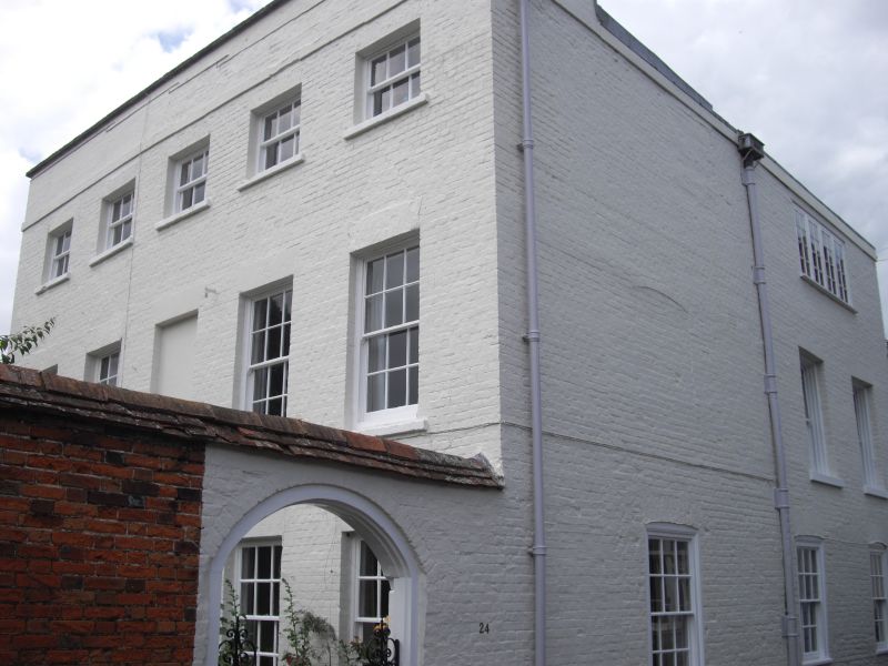
THE CLOSE
1594
No 24
SU 1429 NW 3/37 28.2.52.
II* GV
2.
C18. 3 storey. Colourwashed brick, all headers. Stone band over 2nd floor
windows, and tall parapet with stone coping. Hipped old tile roof. 5 windows
to upper floors, no glazing bars to lst floor right hand,all recessed. On
ground floor only C19 rectangular fanlight, 3 panes, under moulded flat hood.
East front has 3 light casement 2nd floor 2 windows 1st floor and 3 on ground
floor, recessed sashes glazing bars intact.
All the listed buildings in the Close form an outstanding group.
Listing NGR: SU1433029722
External links are from the relevant listing authority and, where applicable, Wikidata. Wikidata IDs may be related buildings as well as this specific building. If you want to add or update a link, you will need to do so by editing the Wikidata entry.


Other nearby listed buildings
