Latitude: 51.0627 / 51°3'45"N
Longitude: -0.327 / 0°19'37"W
OS Eastings: 517334
OS Northings: 130592
OS Grid: TQ173305
Mapcode National: GBR HJN.850
Mapcode Global: FRA B669.VTW
Plus Code: 9C3X3M7F+36
Entry Name: 25 Carfax
Listing Date: 11 April 1986
Grade: II
Source: Historic England
Source ID: 1027497
English Heritage Legacy ID: 298216
ID on this website: 101027497
Location: Horsham, West Sussex, RH12
County: West Sussex
District: Horsham
Electoral Ward/Division: Denne
Parish: Non Civil Parish
Built-Up Area: Horsham
Traditional County: Sussex
Lieutenancy Area (Ceremonial County): West Sussex
Church of England Parish: Horsham St Mary the Virgin
Church of England Diocese: Chichester
Tagged with: Building
This list entry was subject to a Minor Amendment on 28 August 2025 to update the Name and Address and reformat the text to current standards
TQ 13 SE
1/200
CARFAX
No 25
(Formerly listed as No 25 (John Gorman, Estate Agent))
GV
II
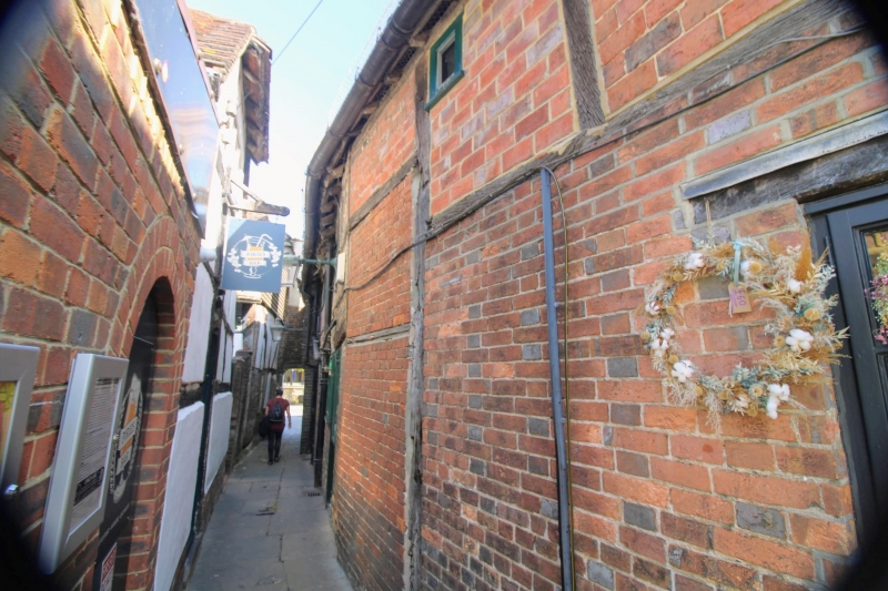
Hall-house, C1400, now altered to shop and storage premises. Timber frame with brick nogging and tile roof, but rendered C19 facade to Carfax. Five bays extending back along Piries Place, with small rear prolongation in brick. Two storeys. The facade on Carfax has a steep gable, solid parapet, and three bays of sash windows, single lights flanking a tripartite window, all without glazing bars. Large shop window to ground floor. The right-hand bay bridges Pirie's Place. The side to the lane has three main posts showing, and small framing to the first floor to these bays. Later openings to ground floor including glazing-bar sashes to the second bay.
Inside, the first two bays were always floored and the communicating door was in the present position on the ground floor. Closed truss between had down braces from post heads, and from crown post which supports a full series of very long, heavy collars. The next truss is said to be nearly complete and similar. Beyond there is believed to have been a two-bay open hall, with a later brick stack inserted in the short second bay. This stack has a small panelled chimney piece of the early C18 facing into the last bay; all bays are now floored. Windows dating from the period of flooring or not long after appear to survive on the yard side.
This early house forms a group with No. 26 and the building behind, which together define the Medieval width of Piries Place.
Listing NGR: TQ1733430592
External links are from the relevant listing authority and, where applicable, Wikidata. Wikidata IDs may be related buildings as well as this specific building. If you want to add or update a link, you will need to do so by editing the Wikidata entry.


Other nearby listed buildings