Latitude: 51.061 / 51°3'39"N
Longitude: -0.3294 / 0°19'45"W
OS Eastings: 517168
OS Northings: 130397
OS Grid: TQ171303
Mapcode National: GBR HJN.FJL
Mapcode Global: FRA B669.TS1
Plus Code: 9C3X3M6C+96
Entry Name: 15, the Causeway
Listing Date: 20 May 1949
Grade: II
Source: Historic England
Source ID: 1353907
English Heritage Legacy ID: 298121
ID on this website: 101353907
Location: Horsham, West Sussex, RH12
County: West Sussex
District: Horsham
Electoral Ward/Division: Denne
Parish: Non Civil Parish
Built-Up Area: Horsham
Traditional County: Sussex
Lieutenancy Area (Ceremonial County): West Sussex
Church of England Parish: Horsham St Mary the Virgin
Church of England Diocese: Chichester
Tagged with: Building
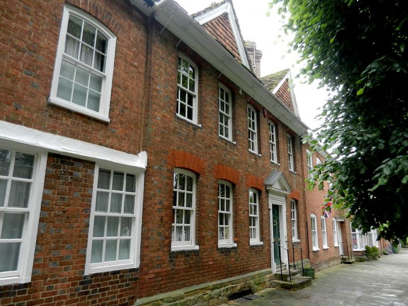
THE CAUSEWAY
1.
1236
(East Side)
No 15
TQ 1730 1/7 20.5.49.
II GV
2.
Timber-framed house refronted in early C18 but retaining 2 gables with moulded
bargeboards from the old house. 2 storeys. 5 windows. Red brick on a stone plinth,
the gables hung with tiles. Horsham slab roof. Moulded eaves cornice. Windows
with segmental heads. Sashes, with wide glazing bars intact. Doorway in frame
up 2 steps, with handrail and pediment over. 6-panel moulded door.
All the listed buildings in The Causeway form a very important group with all the
listed buildings in Market Square and with South Street.
Listing NGR: TQ1716830397
External links are from the relevant listing authority and, where applicable, Wikidata. Wikidata IDs may be related buildings as well as this specific building. If you want to add or update a link, you will need to do so by editing the Wikidata entry.


Other nearby listed buildings