Latitude: 51.061 / 51°3'39"N
Longitude: -0.3299 / 0°19'47"W
OS Eastings: 517135
OS Northings: 130396
OS Grid: TQ171303
Mapcode National: GBR HJN.FF9
Mapcode Global: FRA B669.TKL
Plus Code: 9C3X3M6C+93
Entry Name: 31, the Causeway
Listing Date: 20 May 1949
Grade: II
Source: Historic England
Source ID: 1353910
English Heritage Legacy ID: 298132
ID on this website: 101353910
Location: Horsham, West Sussex, RH12
County: West Sussex
District: Horsham
Electoral Ward/Division: Denne
Parish: Non Civil Parish
Built-Up Area: Horsham
Traditional County: Sussex
Lieutenancy Area (Ceremonial County): West Sussex
Church of England Parish: Horsham St Mary the Virgin
Church of England Diocese: Chichester
Tagged with: Building
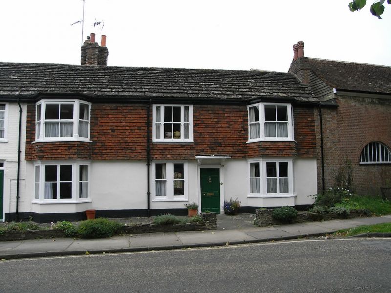
THE CAUSEWAY
1.
1236
(West Side)
No 31
TQ 1730 1/17 20.5.49.
II GV
2.
C18. 2 storeys. 4 windows. Ground floor stuccoed, above tile-hung. The southernmost
window bay is of painted brick. Moulded eaves cornice. Horsham slab roof. 2
bays on both floors. Sash windows, glazing bars missing. 6-panel moulded door in
frame with flat hood over supported on carved brackets.
The Manor House, Stables to the south and Nos 24 to 31 (consec) form a group with
Nos 1 to 7 (odd) Blackhorse Way and with all the listed buildings in South Street.
All the listed buildings in The Causeway form a very important group with all the
listed buildings in Market Square and with South Street.
Listing NGR: TQ1713530396
External links are from the relevant listing authority and, where applicable, Wikidata. Wikidata IDs may be related buildings as well as this specific building. If you want to add or update a link, you will need to do so by editing the Wikidata entry.


Other nearby listed buildings