Latitude: 51.2329 / 51°13'58"N
Longitude: -0.3281 / 0°19'41"W
OS Eastings: 516826
OS Northings: 149517
OS Grid: TQ168495
Mapcode National: GBR HGJ.MVN
Mapcode Global: VHGS7.88FQ
Plus Code: 9C3X6MMC+5Q
Entry Name: Almshouses
Listing Date: 11 June 1973
Grade: II
Source: Historic England
Source ID: 1028886
English Heritage Legacy ID: 289876
ID on this website: 101028886
Location: Dorking, Mole Valley, Surrey, RH4
County: Surrey
District: Mole Valley
Electoral Ward/Division: Dorking South
Parish: Non Civil Parish
Built-Up Area: Dorking
Traditional County: Surrey
Lieutenancy Area (Ceremonial County): Surrey
Church of England Parish: Dorking St Martin
Church of England Diocese: Guildford
Tagged with: Almshouse
1. 1049 Nos 1 to 18 (consec) (Almshouses) TQ 1649 NE 2/219
II
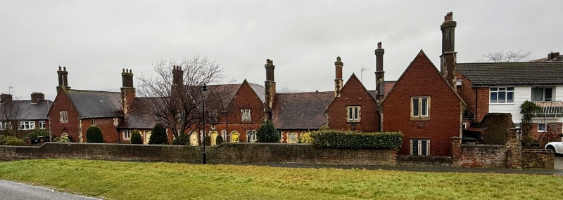
2. Mid C19. Red brick. Steeply pitched red tiled roof. All windows with diamond shaped panes and stone dressings; nearly all of 2 lights. Doorways with 4 centred arches, stone dressings; doors with large hinges. Central projection of one storey and attic with hipped roof; 3 window bays, each with gables. Long and short quoins. 3 two light casement windows. 3 doorways, central one with hoodmould over. String course. Adjoining this at either side, an east-west wing of one storey; 2 windows and 2 doors. Beyond, a cross wing of 1 storey and attic with gable; in each gable end, one 2 light casement window above, and one door below. Tall chimneys set diamond-wise on brick plinths, stone dressings, at either side of gabled wings. Photographs in NMR.
Listing NGR: TQ1694449485
External links are from the relevant listing authority and, where applicable, Wikidata. Wikidata IDs may be related buildings as well as this specific building. If you want to add or update a link, you will need to do so by editing the Wikidata entry.


Other nearby listed buildings