Approximate Location Map
Large Map »
Latitude: 51.353 / 51°21'10"N
Longitude: -1.9012 / 1°54'4"W
OS Eastings: 406974
OS Northings: 161552
OS Grid: SU069615
Mapcode National: GBR 3WH.050
Mapcode Global: VHB4J.0874
Plus Code: 9C3W933X+6G
Entry Name: Parry Monument in Churchyard, 3 Metres South of South Transept, Church of All Saints
Listing Date: 29 April 1987
Grade: II
Source: Historic England
Source ID: 1033778
English Heritage Legacy ID: 311429
ID on this website: 101033778
Location: All Saints Church, All Cannings, Wiltshire, SN10
County: Wiltshire
Civil Parish: All Cannings
Built-Up Area: All Cannings
Traditional County: Wiltshire
Lieutenancy Area (Ceremonial County): Wiltshire
Church of England Parish: All Cannings All Saints
Church of England Diocese: Salisbury
Tagged with: Monument
ALL CANNINGS THE STREET
SU 06 SE
(north east side)
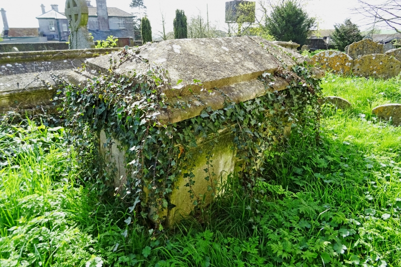
7/9 Parry monument in churchyard,
3m south of south transept,
Church of All Saints
II
Chest tomb, C18. Limestone, with moulded table and raised hipped
centre. Panelled sides divided by draped urn and recessed corner
balusters. Reeded fascia. To Hary Parry and Joseph Parry, died
1805(?).
Listing NGR: SU0697461552
External links are from the relevant listing authority and, where applicable, Wikidata. Wikidata IDs may be related buildings as well as this specific building. If you want to add or update a link, you will need to do so by editing the Wikidata entry.


Other nearby listed buildings
