Approximate Location Map
Large Map »
Latitude: 52.8959 / 52°53'45"N
Longitude: -0.9918 / 0°59'30"W
OS Eastings: 467922
OS Northings: 333637
OS Grid: SK679336
Mapcode National: GBR 9KW.G2H
Mapcode Global: WHFJC.QGXS
Plus Code: 9C4XV2W5+97
Entry Name: Grantham Canal, Canal 9 1/4 Miles Post Approximately 600 Metres South of Colston Bridge
Listing Date: 23 June 1989
Grade: II
Source: Historic England
Source ID: 1045645
English Heritage Legacy ID: 241815
ID on this website: 101045645
Location: Owthorpe, Rushcliffe, Nottinghamshire, NG12
County: Nottinghamshire
District: Rushcliffe
Civil Parish: Colston Bassett
Traditional County: Nottinghamshire
Lieutenancy Area (Ceremonial County): Nottinghamshire
Church of England Parish: Colston Bassett
Church of England Diocese: Southwell and Nottingham
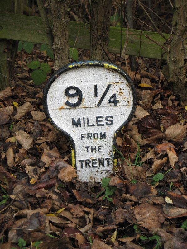
COLSTON BASSETT GRANTHAM CANAL
SK63SE
4/8 Canal 9¼ miles post
- approx. 600 metres
south of Colston
Bridge
- II
Canal milepost. Late C18. Cast-iron post with rounded head and moulded
edge. Raised letters read '9¼ MILES FROM THE TRENT'. The figure 9¼ is
on a riveted-on plate.
The Canal was authorised in 1793 and this section was built by the surveyor
James Green, employed by Lord Middleton of Wollaton Hall.
C Cove-Smith. The Grantham Canal Today, 1974.
Listing NGR: SK6792233637
External links are from the relevant listing authority and, where applicable, Wikidata. Wikidata IDs may be related buildings as well as this specific building. If you want to add or update a link, you will need to do so by editing the Wikidata entry.


Other nearby listed buildings
