Approximate Location Map
Large Map »
Latitude: 53.2578 / 53°15'27"N
Longitude: -0.9772 / 0°58'37"W
OS Eastings: 468330
OS Northings: 373905
OS Grid: SK683739
Mapcode National: GBR PZMR.7W
Mapcode Global: WHFGM.YCVW
Plus Code: 9C5X725F+44
Entry Name: Haughton Park House and Attached Garden Walls
Listing Date: 14 November 1985
Grade: II
Source: Historic England
Source ID: 1045685
English Heritage Legacy ID: 241516
ID on this website: 101045685
Location: Bothamsall, Bassetlaw, Nottinghamshire, DN22
County: Nottinghamshire
District: Bassetlaw
Civil Parish: Bothamsall
Traditional County: Nottinghamshire
Lieutenancy Area (Ceremonial County): Nottinghamshire
Church of England Parish: Bothamsall
Church of England Diocese: Southwell and Nottingham
Tagged with: Building
SK 67 SE
4/13
BOTHAMSALL
RETFORD ROAD
(north side)
Haughton Park House and attached garden walls
II
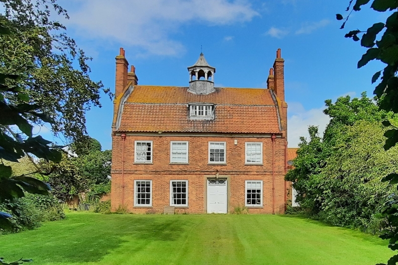
House and attached garden wall. c.1700 with later alterations to
openings. Restored c.1940. Red brick. Mansard pantile roof
with raised brick coped gables and kneelers. 4 red brick
external gable stacks. Single central ridge, wood and lead
cupola, with wooden arcades with keystones and dentil cornice,
topped with pointed shaped roof. Wooden cornice set on a brick
plinth. 2 storeys plus attic, 4 bays. First floor band.
Doorway with double 6 fielded panel doors and traceried overlight
in moulded ashlar surround with keystone. To the right is a
single glazing bar sash, to the left are 2 similar sashes. Above
are 4 similar smaller sashes. In the attic is a single roof
dormer with single tripartite glazing bar casement. To the
right, set back, is a single storey, single bay wing with
projecting C20 bow window. Set on a plinth with band extending
above the windows and ashlar coped parapet. Central glazing bar
sash, flanked by single similar smaller sashes. Attached to the
rear of the house and extending north for 6 metres is a brick
coped wall. This turns at a right angle and extends for 35
metres west and then for 40 metres south, being broken at the
west and south by single doorways with plank doors under
segmental arches. The wall rises to accommodate the doorway. A
wall of later build extends for a further 30 metres east and 18
metres north with a lean-to at the angle. It is broken at the
east by a doorway with plank door under segmental arch.
Listing NGR: SK6833073905
External links are from the relevant listing authority and, where applicable, Wikidata. Wikidata IDs may be related buildings as well as this specific building. If you want to add or update a link, you will need to do so by editing the Wikidata entry.


Other nearby listed buildings
