Approximate Location Map
Large Map »
Latitude: 51.5756 / 51°34'32"N
Longitude: -0.9909 / 0°59'27"W
OS Eastings: 470026
OS Northings: 186784
OS Grid: SU700867
Mapcode National: GBR B2Y.29Q
Mapcode Global: VHDW6.SN0J
Plus Code: 9C3XH2G5+6J
Entry Name: 25, High Street
Listing Date: 13 February 1985
Grade: II
Source: Historic England
Source ID: 1047382
English Heritage Legacy ID: 247127
ID on this website: 101047382
Location: Nettlebed, South Oxfordshire, RG9
County: Oxfordshire
District: South Oxfordshire
Civil Parish: Nettlebed
Built-Up Area: Nettlebed
Traditional County: Oxfordshire
Lieutenancy Area (Ceremonial County): Oxfordshire
Church of England Parish: Nettlebed with Highmoor
Church of England Diocese: Oxford
Tagged with: Building
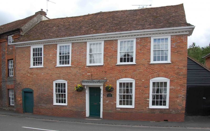
NETTLEBED HIGH STREET
SU7086
(South side)
13/105 No.25
GV II
House. Probably C16 with C18 front and C19 windows. Rendered brick to front;
rubble stone to right return; plain tile roof; brick stacks. 2-storey, 5-
window range. Central 6-panel door with moulded wood surround and flat hood
on shaped brackets. Two 4-pane horned sashes to ground floor. Plank door to
left, 4-panel half-glazed door to right with rectangular overlight. Four 4-
pane horned sashes to first floor, central blind recessed panel. Stack to
rear. Gabled wing to rear has buttresses to ground floor. Interior not
inspected.
Listing NGR: SU7002686784
External links are from the relevant listing authority and, where applicable, Wikidata. Wikidata IDs may be related buildings as well as this specific building. If you want to add or update a link, you will need to do so by editing the Wikidata entry.


Other nearby listed buildings
