Approximate Location Map
Large Map »
Latitude: 51.5756 / 51°34'32"N
Longitude: -0.9906 / 0°59'26"W
OS Eastings: 470046
OS Northings: 186784
OS Grid: SU700867
Mapcode National: GBR B2Y.2CX
Mapcode Global: VHDW6.SN5J
Plus Code: 9C3XH2G5+6Q
Entry Name: The Bull Inn
Listing Date: 24 October 1951
Last Amended: 13 February 1985
Grade: II
Source: Historic England
Source ID: 1047383
English Heritage Legacy ID: 247128
ID on this website: 101047383
Location: Nettlebed, South Oxfordshire, RG9
County: Oxfordshire
District: South Oxfordshire
Civil Parish: Nettlebed
Built-Up Area: Nettlebed
Traditional County: Oxfordshire
Lieutenancy Area (Ceremonial County): Oxfordshire
Church of England Parish: Nettlebed with Highmoor
Church of England Diocese: Oxford
Tagged with: Inn
NETTLEBED HIGH STREET
SU7086
(South side)
13/106 Nos.19 to 23 (odd) (The Bull
24/10/51 Inn)
(Formerly listed as The Bull
Hotel)
GV II
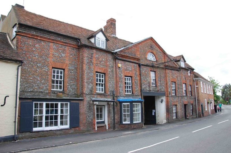
Inn. Early C18 with C19 alterations to ground floor. Grey brick with red
brick dressings; plain tile roof; brick ridge stack. Complex plan. 2
storeys and attic; 7 window range, 1:5:1. Central carriage entrance.
Canted bay window with flat roof and sashes to left, former doorway with
flat hood on shaped brackets and 4-pane window to left end. C20 window
to right and doorway to right end with C20 door. Five 12-pane sashes with
thick glazing bars to first floor. Broken 3-bay pediment to centre of roof
with carved brick mouldings and central half circular window. 2-light gabled
dormers to left and right. One bay ends to left and right recessed. C19
tripartite sash to ground floor left. C20 shopfront to ground floor right.
12-pane sashes with thick glazing bars to left and right. 2-light C19 casement
window to right below eaves.
Listing NGR: SU7005086762
External links are from the relevant listing authority and, where applicable, Wikidata. Wikidata IDs may be related buildings as well as this specific building. If you want to add or update a link, you will need to do so by editing the Wikidata entry.


Other nearby listed buildings
