Latitude: 52.3957 / 52°23'44"N
Longitude: -2.9319 / 2°55'54"W
OS Eastings: 336688
OS Northings: 277933
OS Grid: SO366779
Mapcode National: GBR B9.Q0WB
Mapcode Global: VH76K.41DR
Plus Code: 9C4V93W9+77
Entry Name: Remains of Castle, Hopton Castle
Listing Date: 1 December 1951
Last Amended: 28 May 1987
Grade: I
Source: Historic England
Source ID: 1054935
English Heritage Legacy ID: 257671
Also known as: Hopton Castle tower keep castle with outer bailey 150m north west of Park Cottage
ID on this website: 101054935
Location: Hopton Castle, Shropshire, SY7
County: Shropshire
Civil Parish: Hopton Castle
Traditional County: Shropshire
Lieutenancy Area (Ceremonial County): Shropshire
Church of England Parish: Hopton Castle
Church of England Diocese: Hereford
Tagged with: Castle
SO 37 NE
8/164
HOPTON CASTLE C.P.
HOPTON CASTLE,
Castle, remains of.
(Formerly listed as Hopton Castle)
1.12.51
I
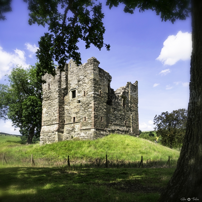
Castle, remains of. Probably early C14 with later additions and alterations.
Regularly coursed shale (traces of former render surviving) with sandstone
ashlar dressings; now roofless. Only keep on roughly circular motte
survives; square plan with clasping buttress-like rectangular corner
turrets. 3 levels with moulded string course to ground floor carried
right around structure; roughly dressed angle quoins. North elevation:
recessed double-chamfered moulded pointed doorway with hoodmould and
outline of former gable above in angle with right turret, which has narrow
rectangular chamfered opening on first floor. Similar openings on both
ground and first floors to left turret. Corbelled projection above
doorway with chamfered stone cap has cusped lancet to centre, similar
lancet to left within larger infilled pointed opening. Chamfered rectangular
window to left of doorway with segmental relieving arch. West elevation:
narrow rectangular openings to turrets. Ruinous segmental-headed doorway
in angle with right turret has segmental-pointed window (mutilated) on
first floor to left. South elevation: narrow rectangular openings to
turrets and large opening to centre retaining fragments of moulding to
jambs; cusped lancet below extending through string course. Slight
rectangular projection in angle with left turret on first floor. East
elevation: narrow rectangular openings to turrets. Broad pointed opening
(mutilated) to left on first floor and square-headed opening with
moulded label in larger infilled opening to right. Rectangular opening
to ground floor on right has segmental relieving arch. Interior.
Inspection not possible at time of resurvey (September 1986) but right
turret on north elevation has spiral staircase. Extensive earthworks
on all sides, especially well-defined to west in what appears to be bailey.
Water-filled moats and several fragments of masonry visible beneath banks.
Scheduled Ancient Monument, County No. 23. B.o.E. p. 153; V.C.H. I. pp.
395-6; G.T. Clark, Medieval Military Architecture, II (1884), pp. 123-5;
Sir James Mackenzie, The Castles of England, II (1897), pp. 135-6.
Listing NGR: SO3668877933
External links are from the relevant listing authority and, where applicable, Wikidata. Wikidata IDs may be related buildings as well as this specific building. If you want to add or update a link, you will need to do so by editing the Wikidata entry.


Other nearby listed buildings