Latitude: 51.126 / 51°7'33"N
Longitude: 0.2574 / 0°15'26"E
OS Eastings: 558065
OS Northings: 138721
OS Grid: TQ580387
Mapcode National: GBR MPY.CX7
Mapcode Global: VHHQD.DYYQ
Plus Code: 9F3247G4+9X
Entry Name: 50 and 52, the Pantiles
Listing Date: 20 May 1952
Grade: II
Source: Historic England
Source ID: 1065932
English Heritage Legacy ID: 168144
ID on this website: 101065932
Location: Royal Tunbridge Wells, Tunbridge Wells, Kent, TN2
County: Kent
District: Tunbridge Wells
Electoral Ward/Division: Pantiles and St Mark's
Parish: Non Civil Parish
Built-Up Area: Royal Tunbridge Wells
Traditional County: Kent
Lieutenancy Area (Ceremonial County): Kent
Church of England Parish: Tunbridge Wells King Charles the Martyr
Church of England Diocese: Rochester
Tagged with: Building
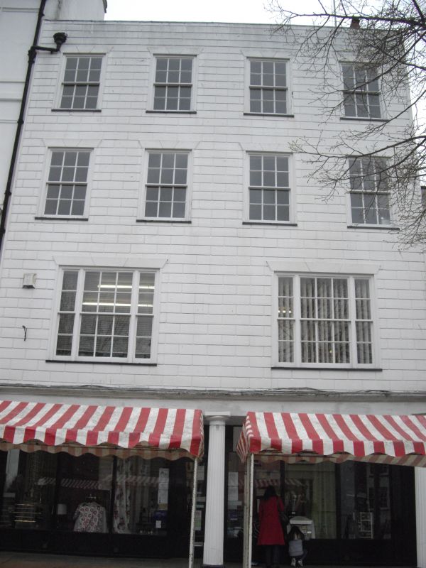
THE PANTILES
1.
1746
(North West Side)
Nos 50 and 52
TQ 5838 NW 1/15 20.5.52.
II GV
2.
C18. No 50 is similar to No 48 but the front of the house itself is built out
over the colonnade on 2 large fluted columns. 4 storeys. 4 sashes with glazing
bars intact but the lst floor has 2 3 light sashes. No 52 stands at the back,
facing London Road. C18. 3 storeys faced with wood, grooved in imitation of
masonry. 2 windows facing west, 3 windows facing south with some glazing bars
intact above ground floor. Modern shop front.
Nos 2 to 28 (even) and Nos 38 to 72 (even) form a group.
Listing NGR: TQ5806438726
External links are from the relevant listing authority and, where applicable, Wikidata. Wikidata IDs may be related buildings as well as this specific building. If you want to add or update a link, you will need to do so by editing the Wikidata entry.


Other nearby listed buildings