Approximate Location Map
Large Map »
Latitude: 51.0683 / 51°4'6"N
Longitude: 0.6872 / 0°41'13"E
OS Eastings: 588366
OS Northings: 133325
OS Grid: TQ883333
Mapcode National: GBR QW3.SNB
Mapcode Global: FRA D6B9.7K9
Plus Code: 9F323M9P+8V
Entry Name: 42, High Street
Listing Date: 8 June 1972
Grade: II
Source: Historic England
Source ID: 1070346
English Heritage Legacy ID: 179754
ID on this website: 101070346
Location: Tenterden, Ashford, Kent, TN30
County: Kent
District: Ashford
Civil Parish: Tenterden
Built-Up Area: Tenterden
Traditional County: Kent
Lieutenancy Area (Ceremonial County): Kent
Tagged with: Building
1.
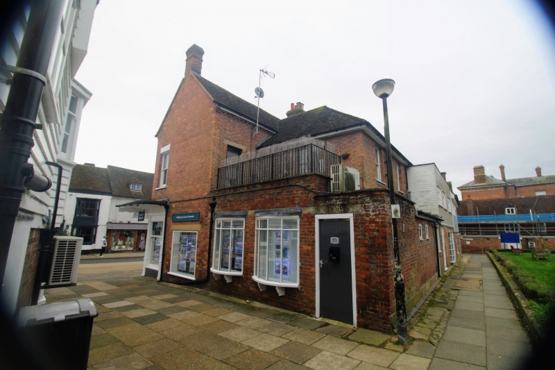
1715 HIGH STREET
(North Side)
No 42
TQ 8833 1/41
II GV
2.
Late C18 to early C19. 2 storeys and attics red brick. Tiled roof has
2 dormers and modillion eaves cornice. 2 sashes with glazing bars missing.
There were originally 2 small bay windows on the ground and 1st floors, but
the east ground floor bay has been cut away to form a modern shopfront with
hood.
All the listed buildings on the north side from Nos 10 to 44,including
Church of St Mildred, form a group.
Listing NGR: TQ8836533328
External links are from the relevant listing authority and, where applicable, Wikidata. Wikidata IDs may be related buildings as well as this specific building. If you want to add or update a link, you will need to do so by editing the Wikidata entry.


Other nearby listed buildings
