Approximate Location Map
Large Map »
Latitude: 53.3915 / 53°23'29"N
Longitude: -2.9404 / 2°56'25"W
OS Eastings: 337558
OS Northings: 388713
OS Grid: SJ375887
Mapcode National: GBR 7FV.X6
Mapcode Global: WH87F.T00S
Plus Code: 9C5V93R5+JR
Entry Name: Rear Entrance Gateway, Steps and Attached Boundary Walls at Toxteth Park Cemetery
Listing Date: 7 September 1999
Grade: II
Source: Historic England
Source ID: 1078256
English Heritage Legacy ID: 477116
ID on this website: 101078256
Location: Toxteth Park Cemetery, Liverpool, Merseyside, L8
County: Liverpool
Electoral Ward/Division: Greenbank
Parish: Non Civil Parish
Built-Up Area: Liverpool
Traditional County: Lancashire
Lieutenancy Area (Ceremonial County): Merseyside
Church of England Parish: Toxteth St Bede with St Clement
Church of England Diocese: Liverpool
Tagged with: Building
SJ3788 LlVERPOOL SMITHDOWN ROAD AND ARUNDEL AVENUE
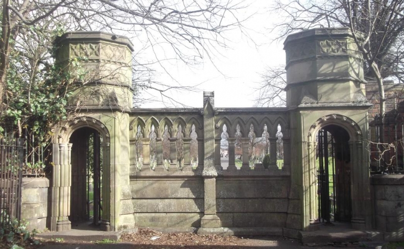
392/33/10119 Rear entrance gateway, steps
and attached boundary walls
at Toxteth Park Cemetery
GV II
Rear entrance gateway with steps and attached boundary walls at municipal cemetery. The gateway is in line with the main axis, and the walls enclose the cemetery on south, east and west sides. 1856, by TD Barry, possibly altered 1884. Gateway and steps ashlar, Gothic Revival style, similar to the Anglican cemetery chapel. 2 square cells, topped with blind traceried octagonal turrets, each with a moulded 4-centred arched doorway with shafts and fleurons, containing a 3-lobed, traceried wrought iron turnstile. On the inner side, each opening is approached by steps with an intermediate landing, formerly with a blind traceried coping to the balustrade wall. To the east, a plaque inscribed "This entrance opened to the public 25th March 1884". On the outer side, each entrance is flanked by a curved wall and wrought iron railing. Between the entrances, an open arcaded screen, with rusticated plinth and central buttress. Attached on either side, boundary wall with buttresses, red brick with blue brick coping, extending approx. 200m east of the entrance and 300m west. This southern wall is higher than the remainder, and has a deep plinth. The return wall to east is approx. 350m long, that to the west approx. 500m
Listing NGR: SJ3755888713
External links are from the relevant listing authority and, where applicable, Wikidata. Wikidata IDs may be related buildings as well as this specific building. If you want to add or update a link, you will need to do so by editing the Wikidata entry.


Other nearby listed buildings
