Approximate Location Map
Large Map »
Latitude: 51.4873 / 51°29'14"N
Longitude: -0.1679 / 0°10'4"W
OS Eastings: 527302
OS Northings: 178069
OS Grid: TQ273780
Mapcode National: GBR 6P.H1
Mapcode Global: VHGQZ.1WL7
Plus Code: 9C3XFRPJ+WR
Entry Name: Public Baths
Listing Date: 7 November 1984
Grade: II
Source: Historic England
Source ID: 1080716
English Heritage Legacy ID: 203637
ID on this website: 101080716
Location: Chelsea, Kensington and Chelsea, London, SW3
County: London
District: Kensington and Chelsea
Electoral Ward/Division: Royal Hospital
Parish: Non Civil Parish
Built-Up Area: Kensington and Chelsea
Traditional County: Middlesex
Lieutenancy Area (Ceremonial County): Greater London
Church of England Parish: St Luke and Christ Church Chelsea
Church of England Diocese: London
Tagged with: Building
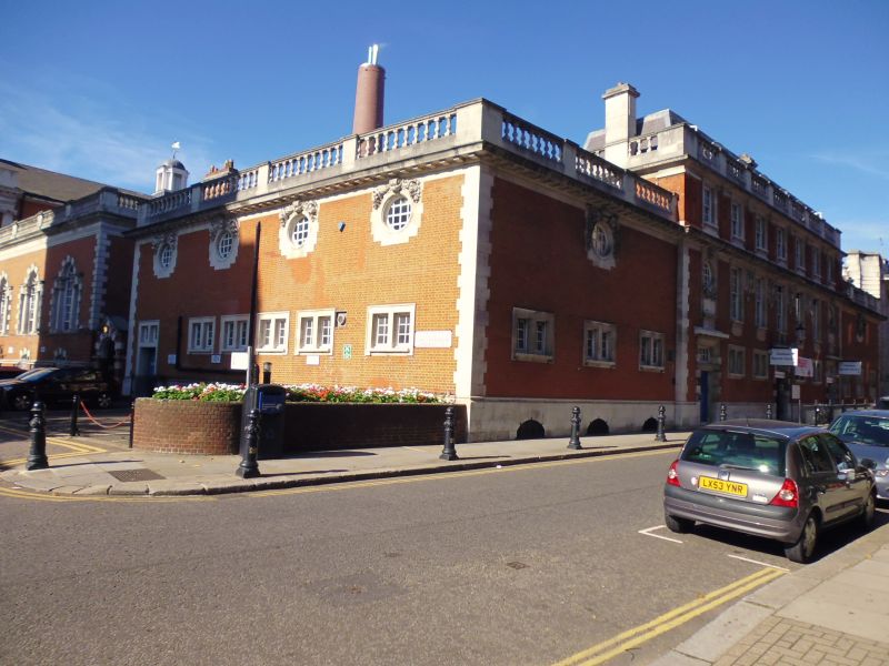
TQ 2778 SW CHELSEA MANOR STREET SW3
56/7
Public Baths
GV
II
Circa 1900. Public Baths. Red brick, stone dressings. English Renaissance. Nine
windows wide, with 7 window centre of 3 storeys with dormers, and lower wings.
Symmetrical. Three rusticated, square-headed doors. Windows square-headed, sashed to
first and second floors. Main cornice above first floor. Carved panels in stone and
brick.
Forms part of Town Hall/Vestry Hall complex, in the same style.
Listing NGR: TQ2730278069
External links are from the relevant listing authority and, where applicable, Wikidata. Wikidata IDs may be related buildings as well as this specific building. If you want to add or update a link, you will need to do so by editing the Wikidata entry.


Other nearby listed buildings
