Approximate Location Map
Large Map »
Latitude: 51.2847 / 51°17'4"N
Longitude: 0.1495 / 0°8'58"E
OS Eastings: 549997
OS Northings: 156145
OS Grid: TQ499561
Mapcode National: GBR S9.SFK
Mapcode Global: VHHPK.JZW1
Plus Code: 9F3274MX+VR
Entry Name: 15-21, Chevening Road
Listing Date: 16 January 1975
Grade: II
Source: Historic England
Source ID: 1085860
English Heritage Legacy ID: 356978
ID on this website: 101085860
Location: Chipstead, Sevenoaks, Kent, TN13
County: Kent
District: Sevenoaks
Civil Parish: Chevening
Built-Up Area: Sevenoaks
Traditional County: Kent
Lieutenancy Area (Ceremonial County): Kent
Church of England Parish: Chevening St Botolph
Church of England Diocese: Rochester
Tagged with: Building
1.
5280
TQ 5056 SW 3/110
TQ 4956 4/110
CHEVENING
CHIPSTEAD
Chevening Road
(West Side)
Nos 15 to 21 (odd)
II
2.
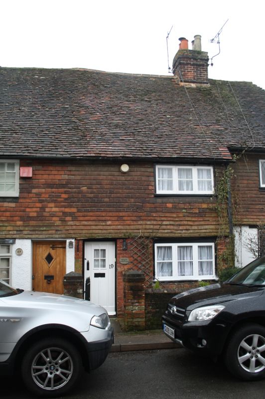
C16 or earlier long timber-framed building now as 4 cottages, each 2 storeys,
1 window. High pitched, hipped tiled roof with 2 ridge stacks. 1st floor tile
hung, ground floor part rendered part brick. Galleted random rubble on returns.
Various odd C19 casements. Nos 19 and 22 have plain boarded doors. Nos 15
and 17 have modern glazed doors and bow windows on ground floor.
Listing NGR: TQ4999756145
External links are from the relevant listing authority and, where applicable, Wikidata. Wikidata IDs may be related buildings as well as this specific building. If you want to add or update a link, you will need to do so by editing the Wikidata entry.


Other nearby listed buildings
