Latitude: 54.1984 / 54°11'54"N
Longitude: -2.5908 / 2°35'26"W
OS Eastings: 361555
OS Northings: 478235
OS Grid: SD615782
Mapcode National: GBR BMBW.XR
Mapcode Global: WH94P.5QKS
Plus Code: 9C6V5CX5+9M
Entry Name: Devils Bridge
Listing Date: 22 March 1983
Grade: I
Source: Historic England
Source ID: 1086899
English Heritage Legacy ID: 75615
ID on this website: 101086899
Location: Kirkby Lonsdale, Westmorland and Furness, Cumbria, LA6
County: Cumbria
District: South Lakeland
Civil Parish: Casterton
Built-Up Area: Kirkby Lonsdale
Traditional County: Westmorland
Lieutenancy Area (Ceremonial County): Cumbria
Church of England Parish: Kirkby Lonsdale Team Ministry
Church of England Diocese: Carlisle
The asset was previously listed twice also under List entry 1138104. This entry was removed from the List on 18 January 2017.
SD 67 NW
19/36
22.3.83
CASTERTON
BRIDGE ROW
(Kirkby Lonsdale CP)
Devil's Bridge
(Formerly listed as: Devil's Bridge (that part in Casterton CP))
I
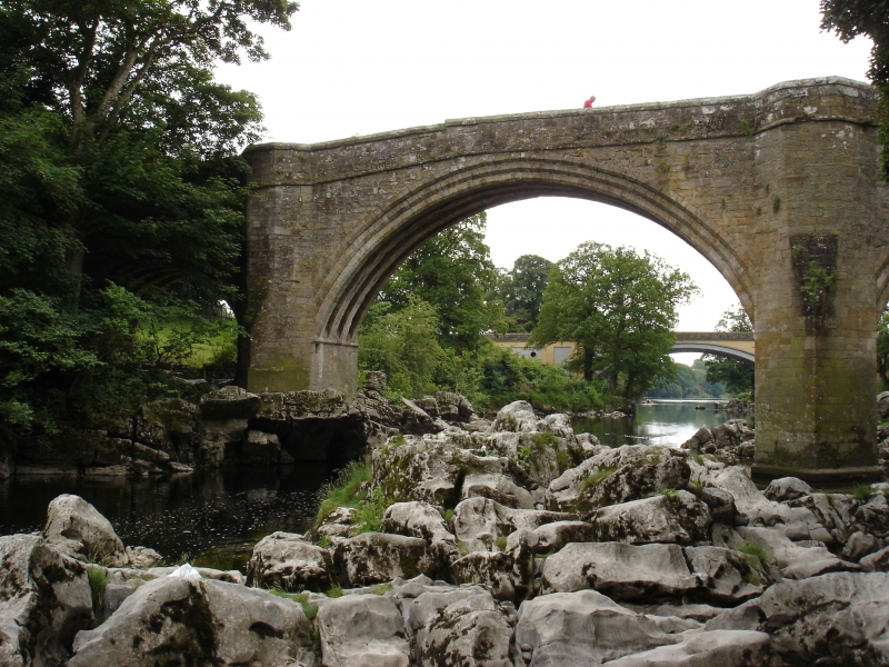
Bridge. C15 or early C16. Ashlar and dressed stone. 3 triple-chamfered
segmental arches, that to east end smaller; 4 ribs to soffits. Piers have
triangular cutwaters to each side, rising to canted refuges; canted abutments.
String course with some waterspouts and coped parapet. Roadway approx. 4m
across. On north side of south parapet an inscription: "CASTERTON KIRK BY
LONSDALE" with arrows. At south side of east end a sundial; a square block on
octagonal shaft with 4 fillets, top has roll moulding and octagonal recess.
Lettering to front apparently reads: "N : CONSTABL C : LONSDALE WAR"; "FEARE GOD
HONER THE : 1673". Carried the Kendal to Skipton road until replaced by Stanley
Bridge, 150m to south, in 1930s. One of the finest medieval bridges in
England. See RCHM Westmorland. Scheduled Ancient Monument.
Listing NGR: SD 61555 78235
External links are from the relevant listing authority and, where applicable, Wikidata. Wikidata IDs may be related buildings as well as this specific building. If you want to add or update a link, you will need to do so by editing the Wikidata entry.


Other nearby listed buildings