Approximate Location Map
Large Map »
Latitude: 54.1957 / 54°11'44"N
Longitude: -2.5944 / 2°35'39"W
OS Eastings: 361318
OS Northings: 477938
OS Grid: SD613779
Mapcode National: GBR BMBX.3P
Mapcode Global: WH94P.3SVV
Plus Code: 9C6V5CW4+77
Entry Name: Milestone
Listing Date: 4 December 1985
Grade: II
Source: Historic England
Source ID: 1165402
English Heritage Legacy ID: 182513
ID on this website: 101165402
Location: Kirkby Lonsdale, Lancaster, Lancashire, LA6
County: Lancashire
District: Lancaster
Civil Parish: Whittington
Traditional County: Lancashire
Lieutenancy Area (Ceremonial County): Lancashire
Church of England Parish: Whittington St Michael the Archangel
Church of England Diocese: Blackburn
Tagged with: Milestone
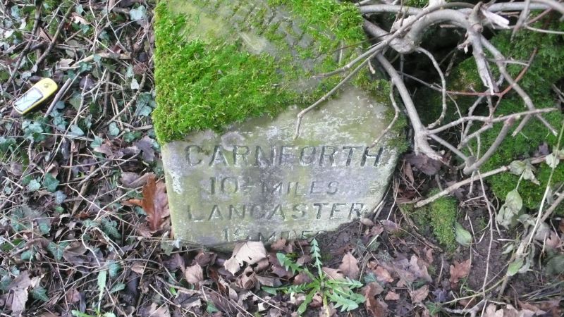
WHITTINGTON B6254
SD 67 NW
2/213 Milestone
GV II
Milestone, mid C19th, sandstone. Triangular plan with sloping top
inscribed: 'WHITTINGTON'. Left-hand face inscribed: 'Ky LONSDALE ½ MILE.'
Right-hand face inscribed: 'CARNFORTH l0½ MILES. LANCASTER 15 MILES'.
Listing NGR: SD6131877938
External links are from the relevant listing authority and, where applicable, Wikidata. Wikidata IDs may be related buildings as well as this specific building. If you want to add or update a link, you will need to do so by editing the Wikidata entry.


Other nearby listed buildings
