Approximate Location Map
Large Map »
Latitude: 54.7147 / 54°42'52"N
Longitude: -3.502 / 3°30'7"W
OS Eastings: 303337
OS Northings: 536557
OS Grid: NY033365
Mapcode National: GBR 3FZX.MP
Mapcode Global: WH5YB.5RNH
Plus Code: 9C6RPF7X+V6
Entry Name: 6, 7 and 8, South Quay
Listing Date: 22 April 2003
Grade: II
Source: Historic England
Source ID: 1096129
English Heritage Legacy ID: 490095
ID on this website: 101096129
Location: Maryport, Cumberland, Cumbria, CA15
County: Cumbria
District: Allerdale
Civil Parish: Maryport
Built-Up Area: Maryport
Traditional County: Cumberland
Lieutenancy Area (Ceremonial County): Cumbria
Church of England Parish: Maryport St Mary with Christ Church
Church of England Diocese: Carlisle
Tagged with: Building
MARYPORT
887/0/10009 SOUTH QUAY
22-APR-03 6, 7 AND 8
II
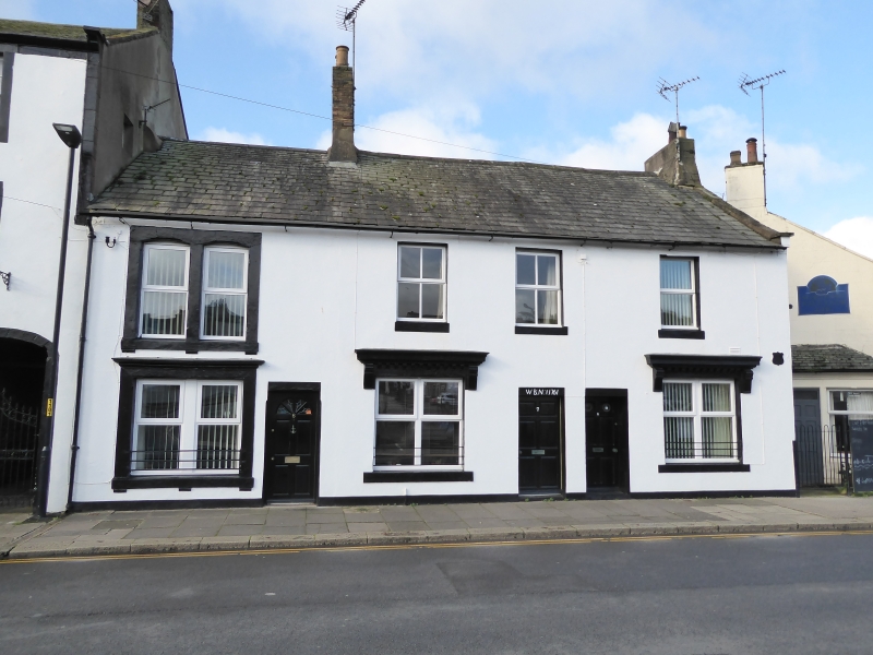
Former quayside offices and warehouses, now residences, dated 1763. Blocked stucco over cobble and rubble sandstone walls, with dressed stone detailing to most openings. Cumbrian slate roof laid to diminishing courses, plain eaves and kneeler to stone coped verge. Rear slope of No 8 is in modern concrete tile. Tall brick stack between 6 and 7 with a low rendered stack to the gable of No 8. 2 storeys, 3 bays overall. Each property is a single bay. No 6 has a late 20th century door with paired late 20th century mock sashes to each floor on the left. Openings are the same size and have the same cill detail; however the ground floor has a flat stone lintel with a moulded cornice over, the first floor window is divided by a square cut mullion, and each side has a segmental head. No 7 has an inscribed lintel, WB No.1 1763 over a panelled door. To the left is a large window with paired late C20 casements under a bracketed moulded cornice; first floor has 2 windows each with 4 pane mock sashes. No.8 has a panelled door and to the right is a large window with the same moulded details as No.7; the windows are paired late C20 casements. Single window to first floor with late 20th century mock sash. Rear (yard) elevation has a number of extensions of various dates and with a variety of window styles.
Believed to have been built for William Blennerhassett, former Lord of the Manor of Flimby who exported coal from the quay in the 18th century. Has a group value with No.1 New Crown Yard, 2 and 3 South Quay and the Naval Club.
Sources:
J.D. Marshall and M. Davies-Shiel, Industrial Archaeology of the Lake Counties, 1977.
E. Hughes, North Country Life in the Eighteenth Century, Vol II: Cumberland and Westmorland 1700-1830, 1965.
C. Roy Hudlestone and R.S. Boumphrey, Cumberland Families and Heraldry, 1978
External links are from the relevant listing authority and, where applicable, Wikidata. Wikidata IDs may be related buildings as well as this specific building. If you want to add or update a link, you will need to do so by editing the Wikidata entry.


Other nearby listed buildings
