Approximate Location Map
Large Map »
Latitude: 50.8581 / 50°51'29"N
Longitude: -3.3931 / 3°23'35"W
OS Eastings: 302046
OS Northings: 107434
OS Grid: ST020074
Mapcode National: GBR LN.V66X
Mapcode Global: FRA 36ST.V83
Plus Code: 9C2RVJ54+6Q
Entry Name: 20 High Street
Listing Date: 11 June 1986
Last Amended: 15 September 2022
Grade: II
Source: Historic England
Source ID: 1105909
English Heritage Legacy ID: 95306
ID on this website: 101105909
Location: Cullompton, Mid Devon, EX15
County: Devon
District: Mid Devon
Civil Parish: Cullompton
Built-Up Area: Cullompton
Traditional County: Devon
Lieutenancy Area (Ceremonial County): Devon
Church of England Parish: Cullompton
Church of England Diocese: Exeter
Tagged with: Building
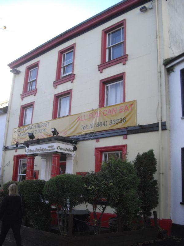
A mid-C19 house, since adapted to a restaurant with accommodation above.
Former house built in the mid-C19. Now a restaurant with accommodation above.
MATERIAL: blocked stucco under a gabled-end, slate roof.
EXTERIOR: of three storeys, with a symmetrical, three-window range. All the windows are two-pane, hornless sashes with margin panes and sills on brackets. There is a plat band between the ground and first floors. The central porch has Tuscan columns set in front of pilasters, all raised on a plinth and approached by three steps. There are depressed panel reveals to the doorcase and a C20 glazed door under a rectangular fanlight. There is a projecting cornice to the eaves with a dentilled band below.
20 High Street is listed at Grade II for the following principal reasons:
Architectural interest:
* dating from the mid-C19, where there is a presumption in favour of listing buildings which retain a significant proportion of their historic fabric;
* a well-proportioned, polite façade, which retains its historic porch, doorcase and windows.
* with the Grade II-listed war memorial opposite and as one of a wider group in the High Street and Higher Bullring which together demonstrate the architectural development and diversity of the town.
External links are from the relevant listing authority and, where applicable, Wikidata. Wikidata IDs may be related buildings as well as this specific building. If you want to add or update a link, you will need to do so by editing the Wikidata entry.


Other nearby listed buildings
