Approximate Location Map
Large Map »
Latitude: 50.8589 / 50°51'32"N
Longitude: -3.3923 / 3°23'32"W
OS Eastings: 302099
OS Northings: 107522
OS Grid: ST020075
Mapcode National: GBR LN.V6D3
Mapcode Global: FRA 36ST.VL2
Plus Code: 9C2RVJ55+H3
Entry Name: 44 High Street
Listing Date: 11 June 1986
Last Amended: 16 August 2022
Grade: II
Source: Historic England
Source ID: 1105911
English Heritage Legacy ID: 95311
ID on this website: 101105911
Location: Cullompton, Mid Devon, EX15
County: Devon
District: Mid Devon
Civil Parish: Cullompton
Built-Up Area: Cullompton
Traditional County: Devon
Lieutenancy Area (Ceremonial County): Devon
Church of England Parish: Cullompton
Church of England Diocese: Exeter
Tagged with: Building
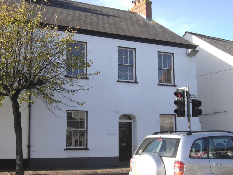
Mid-C19 house, forming one end of a long row.
Mid-C19 house, forming one end of a long row.
PLAN: three-bay plan with central entrance hall.
MATERIALS: cob with a stone plinth, plastered. The slate roof is continuous with No 42 (Grade II listed). Gable end brick chimney stack.
EXTERIOR: two storeys with a symmetrical, three-window range to the front. There are six-over-six hornless sash windows to both the ground and first floors. The two to the ground floor are to either side of a segmentally-headed doorway with six-panel door and fanlight.
INTERIOR: features of note include a C19 dog-leg staircase with ramped handrail and twisted balusters, C19 fireplaces, and C19 joinery including four and six-panel doors and architrave.
44 High Street, Cullompton, is listed at Grade II for the following principal reasons:
Architectural and historic interest:
* as a mid-C19 cob house that retains a significant proportion of its historic fabric.
Group value:
* for its strong group value with 38, 40, and 42 High Street, which together form a row of mid-C19 three-bay houses.
External links are from the relevant listing authority and, where applicable, Wikidata. Wikidata IDs may be related buildings as well as this specific building. If you want to add or update a link, you will need to do so by editing the Wikidata entry.


Other nearby listed buildings
