Approximate Location Map
Large Map »
Latitude: 50.8587 / 50°51'31"N
Longitude: -3.3926 / 3°23'33"W
OS Eastings: 302083
OS Northings: 107498
OS Grid: ST020074
Mapcode National: GBR LN.V6C3
Mapcode Global: FRA 36ST.VHL
Plus Code: 9C2RVJ54+FX
Entry Name: 38 High Street
Listing Date: 11 June 1986
Last Amended: 25 August 2022
Grade: II
Source: Historic England
Source ID: 1105910
English Heritage Legacy ID: 95308
ID on this website: 101105910
Location: Cullompton, Mid Devon, EX15
County: Devon
District: Mid Devon
Civil Parish: Cullompton
Built-Up Area: Cullompton
Traditional County: Devon
Lieutenancy Area (Ceremonial County): Devon
Church of England Parish: Cullompton
Church of England Diocese: Exeter
Tagged with: Building
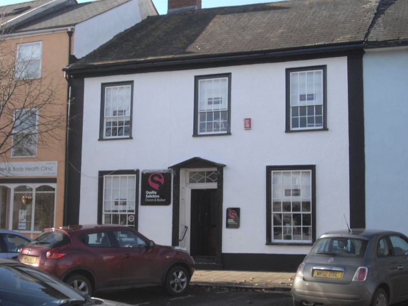
House, now offices, built in the mid-C19.
CULLOMPTON HIGH STREET (west side), ST 00 NW Cullompton 10/118 No 38
GV II
House, now offices, built in the mid-C19.
MATERIALS: cob, plastered over, with a stone plinth beneath. Above is a slate roof continuous with Number 40 (Grade II-listed). There is an axial stack to the left-hand side with a brick shaft.
EXTERIOR: two storeys with a slightly asymmetrical three-window range with strip quoins to the principal elevation. The first-floor windows are hornless sashes, with twelve panes above and eight below. On the ground floor, two larger sash windows, also with twelve panes above and eight below. The central entrance doorway has a pediment, console brackets, strip pilasters and panelled reveals. Panelled entrance door under a rectangular traceried fanlight. The inner door, behind this, has coloured glass to margin panes, matching the overlight above. Forming part of a row.
Listing NGR: ST0208307498
Architectural interest:
* dating from the mid-C19, where there is a presumption in favour of listing buildings which retain a significant proportion of their historic fabric;
* a well-proportioned, polite façade, which retains its historic doorcase and windows.
Group value:
* forming part of a row of four listed buildings, and as one of a wider group in the Higher Bullring which together demonstrate the architectural development and diversity of the town.
External links are from the relevant listing authority and, where applicable, Wikidata. Wikidata IDs may be related buildings as well as this specific building. If you want to add or update a link, you will need to do so by editing the Wikidata entry.


Other nearby listed buildings
