Approximate Location Map
Large Map »
Latitude: 52.0125 / 52°0'45"N
Longitude: -0.3299 / 0°19'47"W
OS Eastings: 514715
OS Northings: 236215
OS Grid: TL147362
Mapcode National: GBR H51.TMF
Mapcode Global: VHGNC.7PF2
Plus Code: 9C4X2M7C+22
Entry Name: St Thomas' Chapel Approximately 20 Metres South of Chapel Farmhouse
Listing Date: 31 October 1966
Grade: II*
Source: Historic England
Source ID: 1113845
English Heritage Legacy ID: 37849
ID on this website: 101113845
Location: Upper Stondon, Central Bedfordshire, SG17
County: Central Bedfordshire
Civil Parish: Meppershall
Traditional County: Bedfordshire
Lieutenancy Area (Ceremonial County): Bedfordshire
Church of England Parish: Meppershall
Church of England Diocese: St.Albans
Tagged with: Chapel
TL 13NW MEPPERSHALL CHAPEL ROAD
3/60
31.10.66 St Thomas' Chapel,
approximately 20 metres S
of Chapel Farmhouse
GV II*
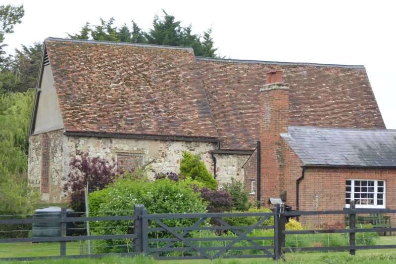
Former chapel, now used as barn. Dedicated to Saint Thomas the Martyr, the
chapel was attached to the Grange belonging to Chicksands Priory. Circa
1175, chancel rebuilt c.1500. Coursed ironstone rubble, coursed limestone
rubble, ashlar dressings, with repairs in red brick. Clay tile roofs. All
original openings blocked with red brick. Consists of aisleless nave and
chancel, chancel roof slightly higher than nave. Nave: 3 bays. Through
purlin roof with straight wind braces. W elevation wall mostly rebuilt in
brick with-pointed-arched doorway, the gable rendered. N and S elevations
each have one early C14 pointed-arched 2 light window to E bay, only the N one
retaining some of its flowing tracery. C12 doorway at W end of N elevation
has enriched round arch with billet and lozenge mouldings, and foliate
capitals below which columns have been remover. Chancel: 2-bays. Original
clasped purlin roof with curved wind braces. Central truss has moulded stone
corbels, S one with grotesque head. E elevation has 3-centred arched
window and rendered gable. N and S elevations each have 2-light window with
flat head to E bay. N elevation has 4-centred doorway opposite single-light
low-side window to S elevation.
Listing NGR: TL1471536215
External links are from the relevant listing authority and, where applicable, Wikidata. Wikidata IDs may be related buildings as well as this specific building. If you want to add or update a link, you will need to do so by editing the Wikidata entry.


Other nearby listed buildings
