Latitude: 51.9987 / 51°59'55"N
Longitude: -0.3558 / 0°21'20"W
OS Eastings: 512972
OS Northings: 234640
OS Grid: TL129346
Mapcode National: GBR H56.LVQ
Mapcode Global: VHFR2.S173
Plus Code: 9C3XXJXV+FM
Entry Name: Clawders Hill Farmhouse
Listing Date: 29 July 1975
Grade: II
Source: Historic England
Source ID: 1113864
English Heritage Legacy ID: 37894
ID on this website: 101113864
Location: Upton End, Central Bedfordshire, SG5
County: Central Bedfordshire
Civil Parish: Shillington
Built-Up Area: Shillington
Traditional County: Bedfordshire
Lieutenancy Area (Ceremonial County): Bedfordshire
Church of England Parish: Shillington and Gravenhurst
Church of England Diocese: St.Albans
Tagged with: Farmhouse
TL 1234 SHILLINGTON & UPTON END ROAD STONDON (East Side) 18/105 29.7.75 Clawders Hill Farmhouse II
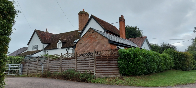
House, now subdivided into 2 properties. C16. Substantial close-studded timber framed structure. Mostly colourwashed roughcast rendered, except for some tile hanging to first floor of W cross-wing. Clay tile roofs. Hall and cross-wings, central block of one storey and attics, cross-wings of 2 storeys. W cross-wing has first floor jetty to N elevaton. S elevation: variety of casements, mostly with glazing bars, 3 to ground floor, 4 to upper floor, including one gabled dormer to central block. 2 part-glazed doors to each end of main block, each with flat hood on cut brackets. Tall rendered multiple ridge stack with moulded cornice to central block. Red brick external stacks to side elevations of cross- wings. Single-storeyed outbuildings adjoin to W and E.
Listing NGR: TL1297234640
External links are from the relevant listing authority and, where applicable, Wikidata. Wikidata IDs may be related buildings as well as this specific building. If you want to add or update a link, you will need to do so by editing the Wikidata entry.


Other nearby listed buildings