Approximate Location Map
Large Map »
Latitude: 51.8856 / 51°53'8"N
Longitude: -0.5228 / 0°31'22"W
OS Eastings: 501762
OS Northings: 221813
OS Grid: TL017218
Mapcode National: GBR G50.LNN
Mapcode Global: VHFRC.WVGW
Plus Code: 9C3XVFPG+6V
Entry Name: 26, West Street
Listing Date: 4 March 1976
Grade: II
Source: Historic England
Source ID: 1114602
English Heritage Legacy ID: 35770
ID on this website: 101114602
Location: Dunstable, Central Bedfordshire, LU6
County: Central Bedfordshire
Civil Parish: Dunstable
Built-Up Area: Dunstable
Traditional County: Bedfordshire
Lieutenancy Area (Ceremonial County): Bedfordshire
Church of England Parish: Dunstable
Church of England Diocese: St.Albans
Tagged with: Building
1.
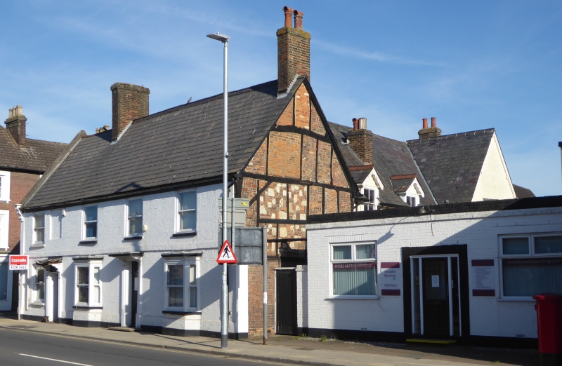
5125 WEST STREET
(North Side)
No 26
TL 012l NE 1/32
II
2.
Late C18 front of whitewashed brick, Welsh slated roof. 2 storeys, first floor
band. Timber framed east side gable. 4 sash window to first floor, ground floor
pair of early C19 bay windows flanking door under cornice hood.
Listing NGR: TL0176221813
External links are from the relevant listing authority and, where applicable, Wikidata. Wikidata IDs may be related buildings as well as this specific building. If you want to add or update a link, you will need to do so by editing the Wikidata entry.


Other nearby listed buildings
