Approximate Location Map
Large Map »
Latitude: 52.1884 / 52°11'18"N
Longitude: -2.1132 / 2°6'47"W
OS Eastings: 392360
OS Northings: 254472
OS Grid: SO923544
Mapcode National: GBR 2HM.LLL
Mapcode Global: VH92W.B865
Plus Code: 9C4V5VQP+9P
Entry Name: North Farmhouse
Listing Date: 3 August 1972
Grade: II
Source: Historic England
Source ID: 1116912
English Heritage Legacy ID: 442522
ID on this website: 101116912
Location: Broughton Hackett, Wychavon, Worcestershire, WR7
County: Worcestershire
District: Wychavon
Civil Parish: Broughton Hackett
Traditional County: Worcestershire
Lieutenancy Area (Ceremonial County): Worcestershire
Church of England Parish: Broughton Hackett
Church of England Diocese: Worcester
Tagged with: Farmhouse
BROUGHTON HACKETT BROUGHTON HACKETT
1.
2301
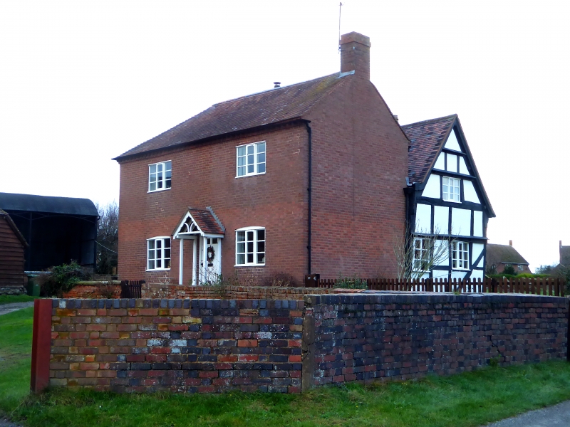
North Farmhouse
SO 95 SW 5/192
II
2.
Early Cl7. Timber frame and plaster with later brick addition adjoining
and early C19 brick extension to west, with 2-storeys, 2 windows, casements,
centre door. Tile roof.
Listing NGR: SO9236054472
External links are from the relevant listing authority and, where applicable, Wikidata. Wikidata IDs may be related buildings as well as this specific building. If you want to add or update a link, you will need to do so by editing the Wikidata entry.


Other nearby listed buildings
