Approximate Location Map
Large Map »
Latitude: 50.6085 / 50°36'30"N
Longitude: -1.9581 / 1°57'29"W
OS Eastings: 403057
OS Northings: 78758
OS Grid: SZ030787
Mapcode National: GBR 459.PS1
Mapcode Global: FRA 67SG.GYT
Plus Code: 9C2WJ25R+CP
Entry Name: 44 and 44A, High Street
Listing Date: 21 March 1983
Grade: II
Source: Historic England
Source ID: 1119933
English Heritage Legacy ID: 108184
ID on this website: 101119933
Location: Swanage, Dorset, BH19
County: Dorset
Civil Parish: Swanage
Built-Up Area: Swanage
Traditional County: Dorset
Lieutenancy Area (Ceremonial County): Dorset
Church of England Parish: Swanage St Mary the Virgin
Church of England Diocese: Salisbury
Tagged with: Building
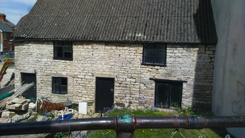
HIGH STREET
1.
5190
(north side)
Nos 44 and 44a
SZ 0378 NW 5/58
II GV
2.
Probably C18. Originally 2 cottages, both now used as workshops, set back from and
below the present street line. Purbeck Stone walls, corrugated asbestos roof, probably
replacing Purbeck Stone. Two storeys. Flush panel doors to each cottage, and casement
windows on ground and first floors. Evidence of earlier blocked openings. An early
survival, although altered. RCHM Monument 26.
Listing NGR: SZ0305778758
External links are from the relevant listing authority and, where applicable, Wikidata. Wikidata IDs may be related buildings as well as this specific building. If you want to add or update a link, you will need to do so by editing the Wikidata entry.


Other nearby listed buildings
