Approximate Location Map
Large Map »
Latitude: 50.6085 / 50°36'30"N
Longitude: -1.9577 / 1°57'27"W
OS Eastings: 403086
OS Northings: 78750
OS Grid: SZ030787
Mapcode National: GBR 459.PWC
Mapcode Global: FRA 67SG.H3J
Plus Code: 9C2WJ25R+9W
Entry Name: The Arcade
Listing Date: 21 March 1983
Grade: II
Source: Historic England
Source ID: 1152394
English Heritage Legacy ID: 108183
ID on this website: 101152394
Location: Swanage, Dorset, BH19
County: Dorset
Civil Parish: Swanage
Built-Up Area: Swanage
Traditional County: Dorset
Lieutenancy Area (Ceremonial County): Dorset
Church of England Parish: Swanage St Mary the Virgin
Church of England Diocese: Salisbury
Tagged with: Architectural structure
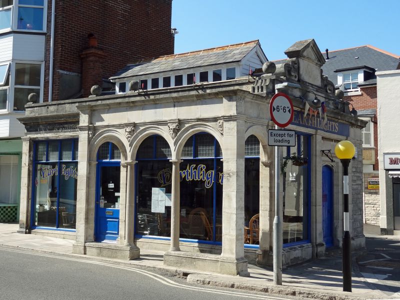
HIGH STREET
1.
5190
(north side)
No 36
(The Arcade)
SZ 0378 NW 5/57
II GV
2.
Dated 1896. Purbeck Stone walls, slate roof behind parapet. Single-storey building
used as a shop, Projecting arcade facing High Street, with 3 arches carried on
Tuscan columns with carved heads in the spandrels. East elevation finished with a
pediment rising from the parapet, with console brackets. "Tudor" style entrance door
below this. Probably designed as a terminal feature at the junction of High Street
and Kings Road East.
Listing NGR: SZ0308678750
External links are from the relevant listing authority and, where applicable, Wikidata. Wikidata IDs may be related buildings as well as this specific building. If you want to add or update a link, you will need to do so by editing the Wikidata entry.


Other nearby listed buildings
