Approximate Location Map
Large Map »
Latitude: 51.5716 / 51°34'17"N
Longitude: -0.7764 / 0°46'35"W
OS Eastings: 484895
OS Northings: 186571
OS Grid: SU848865
Mapcode National: GBR D5W.GHH
Mapcode Global: VHDWB.HRDK
Plus Code: 9C3XH6CF+MC
Entry Name: 13, High Street
Listing Date: 31 January 1974
Grade: II
Source: Historic England
Source ID: 1125061
English Heritage Legacy ID: 46212
ID on this website: 101125061
Location: Marlow, Buckinghamshire, SL7
County: Buckinghamshire
Civil Parish: Marlow
Built-Up Area: Marlow
Traditional County: Buckinghamshire
Lieutenancy Area (Ceremonial County): Buckinghamshire
Church of England Parish: Great Marlow with Marlow Bottom, Little Marlow and Bisham
Church of England Diocese: Oxford
Tagged with: Building
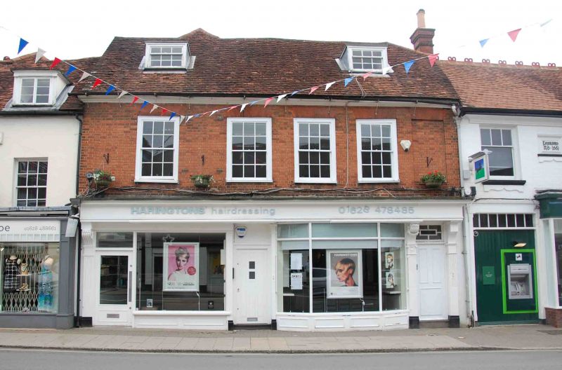
HIGH STREET
1.
l385
(North East Side)
No 13
SU 8486 1/12
II
2.
Cl8 altered. Formerly one house. 2 storeys and attic. Brick upper part
with moulded eaves cornice and old tile roof. 4 windows on lst floor
(one false) 2 dormers. Glazing bars. Cornice. C19 shops framed with
pilasters and entablature on ground floor. Door on right with console
brackets,
Listing NGR: SU8489586578
External links are from the relevant listing authority and, where applicable, Wikidata. Wikidata IDs may be related buildings as well as this specific building. If you want to add or update a link, you will need to do so by editing the Wikidata entry.


Other nearby listed buildings
