Approximate Location Map
Large Map »
Latitude: 51.5717 / 51°34'18"N
Longitude: -0.7765 / 0°46'35"W
OS Eastings: 484892
OS Northings: 186576
OS Grid: SU848865
Mapcode National: GBR D5W.GHH
Mapcode Global: VHDWB.HRCJ
Plus Code: 9C3XH6CF+MC
Entry Name: 11, High Street
Listing Date: 31 January 1974
Grade: II
Source: Historic England
Source ID: 1125105
English Heritage Legacy ID: 46211
ID on this website: 101125105
Location: Marlow, Buckinghamshire, SL7
County: Buckinghamshire
Civil Parish: Marlow
Built-Up Area: Marlow
Traditional County: Buckinghamshire
Lieutenancy Area (Ceremonial County): Buckinghamshire
Church of England Parish: Great Marlow with Marlow Bottom, Little Marlow and Bisham
Church of England Diocese: Oxford
Tagged with: Building
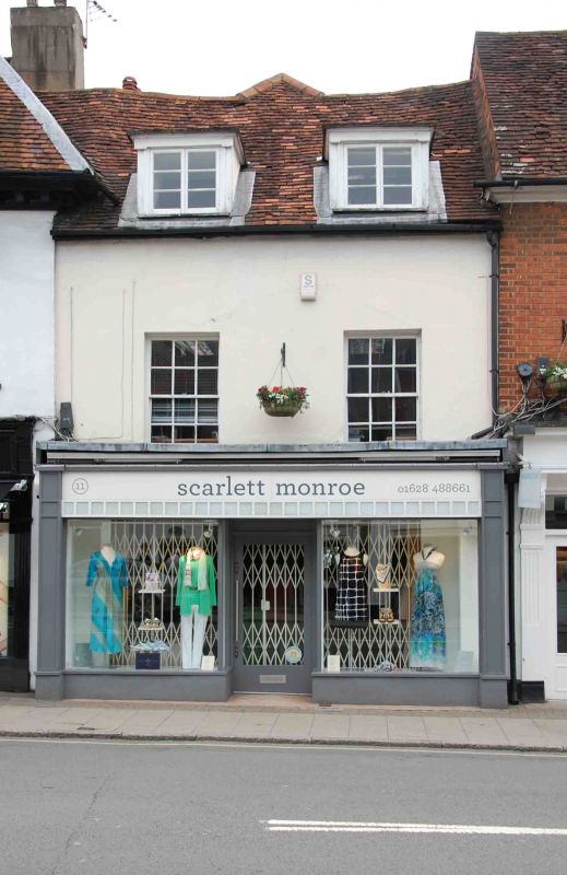
1385 HIGH STREET
(North East Side)
No 11
SU 8486 1./101
II
2.
Cl8. 2 storeys, stucco, old tile roof. 2 modern flat topped dormers with casements. 2 windows. Glazing bars on 1st floor intact. fl1odern shop front.
Listing NGR: SU8492886526
External links are from the relevant listing authority and, where applicable, Wikidata. Wikidata IDs may be related buildings as well as this specific building. If you want to add or update a link, you will need to do so by editing the Wikidata entry.


Other nearby listed buildings
