Approximate Location Map
Large Map »
Latitude: 50.2122 / 50°12'43"N
Longitude: -5.4797 / 5°28'46"W
OS Eastings: 151837
OS Northings: 40482
OS Grid: SW518404
Mapcode National: GBR DXV3.W8F
Mapcode Global: VH12D.YXZQ
Plus Code: 9C2P6G6C+V4
Entry Name: St Andrews House
Listing Date: 22 December 1972
Last Amended: 25 November 2005
Grade: II
Source: Historic England
Source ID: 1136936
English Heritage Legacy ID: 69083
ID on this website: 101136936
Location: St Ives, Cornwall, TR26
County: Cornwall
Civil Parish: St. Ives
Built-Up Area: St Ives
Traditional County: Cornwall
Lieutenancy Area (Ceremonial County): Cornwall
Church of England Parish: St Ives
Church of England Diocese: Truro
Tagged with: House
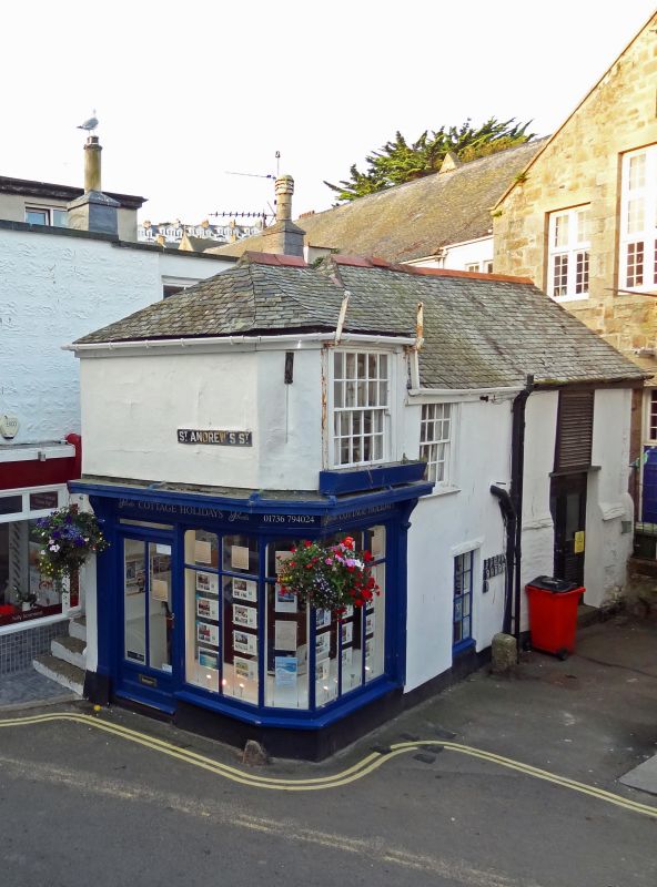
678/1/129 ST ANDREW'S STREET
22-DEC-1972 (West side)
St Andrew's House
(Formerly listed as:
ST ANDREW'S STREET
24
KATMANDU)
II
Early C19. Painted brick; stucco above ground floor. Slurried slate roof. Two storeys. Corner site, three windows on north elevation, sashes in moulded cases, with glazing bars, Victorian corner shop of six ogee headed lights, cornice and console brackets.
Listing NGR: SW5183140486
External links are from the relevant listing authority and, where applicable, Wikidata. Wikidata IDs may be related buildings as well as this specific building. If you want to add or update a link, you will need to do so by editing the Wikidata entry.


Other nearby listed buildings
