Latitude: 54.5797 / 54°34'47"N
Longitude: -1.2337 / 1°14'1"W
OS Eastings: 449630
OS Northings: 520772
OS Grid: NZ496207
Mapcode National: GBR MHTH.Q2
Mapcode Global: WHD70.04TY
Plus Code: 9C6WHQH8+VG
Entry Name: New Exchange Buildings
Listing Date: 28 July 1988
Last Amended: 5 March 2024
Grade: II
Source: Historic England
Source ID: 1139830
English Heritage Legacy ID: 59777
ID on this website: 101139830
Location: Middlesbrough, North Yorkshire, TS2
County: Middlesbrough
Electoral Ward/Division: Central
Parish: Non Civil Parish
Built-Up Area: Middlesbrough
Traditional County: Yorkshire
Lieutenancy Area (Ceremonial County): North Yorkshire
Church of England Parish: Middlesbrough All Saints
Church of England Diocese: York
Tagged with: Building
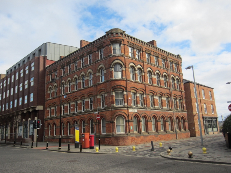
Offices, 1874 by WH Blessley, now (2023) in residential and office use.
Offices, 1874 by WH Blessley, now in residential and office use.
MATERIALS: brick, in Flemish bond, with sandstone dressings, a Welsh slate roof with rebuilt transverse ridge stacks.
PLAN: the building occupies a corner position with a U-shaped plan around a small courtyard to the rear. The west elevation faces Queen’s Square where the principal entrances are located, and the south elevation faces onto Bridge Street East.
EXTERIOR: the building has four storeys with eight bays to Queen’s Square and seven bays to Bridge Street East. Additionally, both elevations have a quadrant bay.
Queen’s Square elevation: the ground floor has a deep plinth, with arched-arcaded window openings above. The original entrance in the fifth bay has a renewed panelled door and fanlight flanked by modern panelled doors also with fan lights within former window openings. The upper floors are divided between the second and third bay, and the seventh and eighth bay by pilaster strips. The first floor has a segment-arcade with continuous hoodmould, sill band and blind tympana. The second floor is round-arcaded with pointed hoodmoulds, whilst the third floor has square-headed windows under shaped lintels and a continuous hoodmould; both floors with moulded sill bands. There are timber sashes throughout. Below the hipped and gabled shallow-pitched roof is a corbelled eaves cornice, with a short-curved parapet over the quadrant bay.
The Bridge Street East elevation is seven bays with a quadrant right end bay. The elevation is similarly styled to the Queen’s Square elevation.
Middlesbrough owes its existence to the industrial revolution and a demand for coal and steel. Its growth from a small farming community of around 25 people in 1801 to one of over 90,000 inhabitants by the end of the C19 has been described as unprecedented in British urban history.
The growth was spearheaded by a group of Quaker businessmen headed by Joseph Pease of Darlington who speculatively purchased the Middlesbrough estate, realising the potential of the area, planned the town alongside a new port, and extending the Stockton and Darlington Railway to the banks of the Tees in 1828.
The new town was developed in the 1830s in a grid pattern in an area north of the station and centred around the ‘Market Square’, now the location of the Old Town Hall and Clock Tower (both 1846 and Grade II listed). Further expansion came in the 1850s with the discovery of substantial ironstone deposits in the Cleveland Hills, exploited by the industrialist Henry Bolckow (1806-1878) and John Vaughan (1799-1868) who constructed the town’s first iron foundry. The town was incorporated in 1853, and by 1865 Middlesbrough had become the world’s largest producer of iron, generating a third of Britain’s output. The switch to steel saw Middlesbrough as one of Britain’s leading steel production centres. The area around the station became the focus of Middlesbrough’s financial and commercial district, undergoing significant development in 1870s.
Following the Second World War, Middlesbrough suffered from industrial decline and large parts of the old town were cleared; the Royal Exchange, once a focal point for the financial and corporate life of the town, was demolished to make way for the elevated A66 road in 1985.
New Exchange Buildings was constructed as offices in 1874. The architect, William Henry Blessley (1841-1936), designed numerous public and commercial buildings in Middlesbrough. He was born in Highgate, Middlesex, the son of an independent minister. Although little is known about the early years of his profession, he is recorded as practising as an architect and surveyor in Middlesbrough by 1871. He was responsible for a number of the buildings in Exchange Place and Exchange Square as well as Zetland Road, which formed the commercial hub around the former Royal Exchange. He also designed many buildings in the vicinity of Middlesbrough, including the Albert Park public house (circa 1868), a Quaker meeting house and classrooms in Dunning Road (1873), St Peter, Lower East Street (1874), Linthorpe Community Primary School (1874), Christ Church, Eston (1883-1884), and the apse of St Hilda, Market Place (1890).
New Exchange Buildings, Queens Square, Middlesbrough, is listed at Grade II for the following principal reasons:
Architectural interest:
* designed by the prolific architect W H Blessley, the building is a good example of the Italianate style with Venetian influences, which was a popular choice for commercial building in the 1860s;
* the polychromatic brickwork and sandstone dressings make this a striking building intended to convey the wealth and status of the occupying businesses;
* it occupies a prominent corner location that makes a valuable contribution to the high-quality Victorian townscape, including nearby listed buildings designed as part of the financial and commercial district, many of which were also designed by Blessley.
Historic interest:
* it forms part of Middlesbrough Victorian financial and commercial quarter, an area that was integral to the town’s economic success and rapid growth in the latter half of the C19, becoming the world’s leading producer of pig iron, and later one of the country’s major steel centres.
External links are from the relevant listing authority and, where applicable, Wikidata. Wikidata IDs may be related buildings as well as this specific building. If you want to add or update a link, you will need to do so by editing the Wikidata entry.


Other nearby listed buildings