Latitude: 50.3144 / 50°18'51"N
Longitude: -5.2143 / 5°12'51"W
OS Eastings: 171254
OS Northings: 50989
OS Grid: SW712509
Mapcode National: GBR Z4.K7DP
Mapcode Global: VH125.KCRC
Plus Code: 9C2P8Q7P+P7
Entry Name: Chimney at SW712510
Listing Date: 31 October 1988
Grade: II
Source: Historic England
Source ID: 1141507
English Heritage Legacy ID: 63792
ID on this website: 101141507
Location: St Agnes, Cornwall, TR5
County: Cornwall
Civil Parish: St. Agnes
Traditional County: Cornwall
Lieutenancy Area (Ceremonial County): Cornwall
Church of England Parish: St Agnes
Church of England Diocese: Truro
Tagged with: Chimney
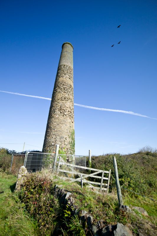
ST AGNES HIGHER BAL
SW 75 SW
4/161 Chimney at SW712510
-
GV II
Detached mine chimney probably part of Polberro Mine. Circa late C19. Killas rubble with brick to upper part.
Round on plan.
Tapered chimney with no collar between stone and brick masonry.
Listing NGR: SW7125450988
External links are from the relevant listing authority and, where applicable, Wikidata. Wikidata IDs may be related buildings as well as this specific building. If you want to add or update a link, you will need to do so by editing the Wikidata entry.


Other nearby listed buildings