Approximate Location Map
Large Map »
Latitude: 50.8295 / 50°49'46"N
Longitude: -4.5458 / 4°32'44"W
OS Eastings: 220813
OS Northings: 106420
OS Grid: SS208064
Mapcode National: GBR K2.X280
Mapcode Global: FRA 16CX.2VT
Plus Code: 9C2QRFH3+RM
Entry Name: Nanny Moore's Bridge
Listing Date: 9 September 1985
Grade: II
Source: Historic England
Source ID: 1141818
English Heritage Legacy ID: 64803
ID on this website: 101141818
Location: Bude, Cornwall, EX23
County: Cornwall
Civil Parish: Bude-Stratton
Built-Up Area: Bude
Traditional County: Cornwall
Lieutenancy Area (Ceremonial County): Cornwall
Church of England Parish: Bude Haven
Church of England Diocese: Truro
Tagged with: Bridge
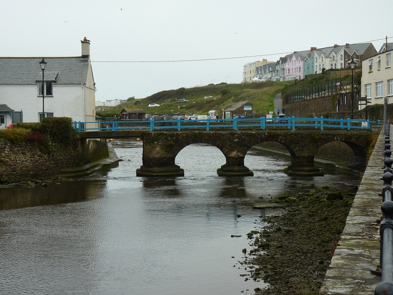
SS 2006 - 2106 BUDE-STRATTON THE STRAND, BUDE
11/219 Nanny Moore's Bridge
-
GV II
Packhorse and cart bridge across the River Neet. C18 or earlier. Stone rubble.
3-span bridge with segmental arches with keystones and cutwaters on both sides.
Bridge completed on south by cantilevered bridge over channel to allow passage of
boats. No parapets. Nanny Moore's Bridge leads to the site of Efford Mill, the
tidemill built in the late C16 by the Arundells of Trerice. A "passe" over the
river at Efford Hill is mentioned in a contemporary account of the Battle of
Stamford Hill in 1643, but this may refer to a ford. An C18 watercolour
illustrates the bridge and pontoon. The bridge was formerly known as Bude Bridge
and renamed in the C19 after a dipper who lived in a nearby cottage. Rennie Bere
and Brian Dudley Stamp, The Book of Stratton and Bude (1980).
Listing NGR: SS2081306420
External links are from the relevant listing authority and, where applicable, Wikidata. Wikidata IDs may be related buildings as well as this specific building. If you want to add or update a link, you will need to do so by editing the Wikidata entry.


Other nearby listed buildings
