Approximate Location Map
Large Map »
Latitude: 54.2627 / 54°15'45"N
Longitude: -0.8587 / 0°51'31"W
OS Eastings: 474437
OS Northings: 485829
OS Grid: SE744858
Mapcode National: GBR QMF4.WP
Mapcode Global: WHF9V.S38Y
Plus Code: 9C6X747R+3G
Entry Name: Bridge Approximately 35 Metres South West of the Village Hall
Listing Date: 10 November 1953
Last Amended: 27 August 1987
Grade: II
Source: Historic England
Source ID: 1149744
English Heritage Legacy ID: 382514
ID on this website: 101149744
Location: Sinnington, North Yorkshire, YO62
County: North Yorkshire
District: Ryedale
Civil Parish: Sinnington
Built-Up Area: Sinnington
Traditional County: Yorkshire
Lieutenancy Area (Ceremonial County): North Yorkshire
Tagged with: Bridge
SE 78 NW
8/96
10.11.53
SINNINGTON
THE GREEN
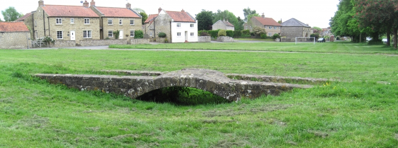
Bridge approximately 35 metres south-west of the Village Hall
(formerly listed as Bridge on Green)
II
Flood bridge. c1769; partly rebuilt in 1794; restored 1966. Roughly-
dressed sandstone. Single span. Segmental arch of voussoirs approximately
0.7 metre high in the centre of a raised causeway. The bridge and causeway
span a dry ditch and were constructed to provide passage for packhorses
across floodwater from the nearby River Seven. The bridge as built was a
hump-backed packhorse bridge with a segmental arch. Following the silting
up of the original flood channel, the approaches were banked up by spreading
large stones over the causeway, thus reducing the slope of the hump.
Parapets, portions of which remain, were added at this time. J McDonnell
"The Bridge on Sinnington Green", The Rydedale Historian, No 2, April 1966,
pp 50-53.
Listing NGR: SE7443785829
External links are from the relevant listing authority and, where applicable, Wikidata. Wikidata IDs may be related buildings as well as this specific building. If you want to add or update a link, you will need to do so by editing the Wikidata entry.


Other nearby listed buildings
