Approximate Location Map
Large Map »
Latitude: 54.2625 / 54°15'45"N
Longitude: -0.8596 / 0°51'34"W
OS Eastings: 474377
OS Northings: 485808
OS Grid: SE743858
Mapcode National: GBR QMF4.PR
Mapcode Global: WHF9V.R4V3
Plus Code: 9C6X747R+24
Entry Name: Sinnington Bridge
Listing Date: 10 November 1953
Grade: II
Source: Historic England
Source ID: 1214217
English Heritage Legacy ID: 382513
ID on this website: 101214217
Location: Sinnington, North Yorkshire, YO62
County: North Yorkshire
District: Ryedale
Civil Parish: Sinnington
Built-Up Area: Sinnington
Traditional County: Yorkshire
Lieutenancy Area (Ceremonial County): North Yorkshire
Tagged with: Bridge
SINNINGTON THE GREEN
SE 78 NW
8/95 Sinnington Bridge
10.11.53
GV II
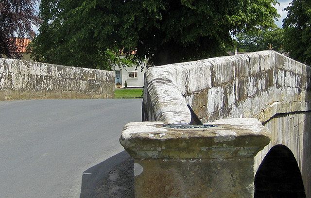
Bridge. 1769 on sundial. Dressed sandstone. Single span. Segmental arch
of raised-and-chamfered voussoirs on upstream side and shaped flush
voussoirs on the downstream side. Plain raised band over arch. Parapet
with chamfered coping, raked to centre, terminates in square-section piers
with stepped cornices and shallow pyramidal caps. The south-west pier has
no cap but carries a sundial made by Richardson of Helmsley and dated 1769.
Listing NGR: SE7437785808
External links are from the relevant listing authority and, where applicable, Wikidata. Wikidata IDs may be related buildings as well as this specific building. If you want to add or update a link, you will need to do so by editing the Wikidata entry.


Other nearby listed buildings
