Approximate Location Map
Large Map »
Latitude: 51.7938 / 51°47'37"N
Longitude: -2.4267 / 2°25'36"W
OS Eastings: 370664
OS Northings: 210661
OS Grid: SO706106
Mapcode National: GBR FZ.Y0NR
Mapcode Global: VH875.W5FP
Plus Code: 9C3VQHVF+G8
Entry Name: Unidentified Monument, About 4M South-West of Priest's Door in Churchyard of Church of St Mary
Listing Date: 9 December 1986
Grade: II
Source: Historic England
Source ID: 1152429
English Heritage Legacy ID: 132269
ID on this website: 101152429
Location: St Mary's Church, Arlingham, Stroud, Gloucestershire, GL2
County: Gloucestershire
District: Stroud
Civil Parish: Arlingham
Built-Up Area: Arlingham
Traditional County: Gloucestershire
Lieutenancy Area (Ceremonial County): Gloucestershire
Church of England Parish: Arlingham St Mary the Virgin
Church of England Diocese: Gloucester
Tagged with: Monument
ARLINGHAM CHURCH ROAD
SO 71 SW
(west side)
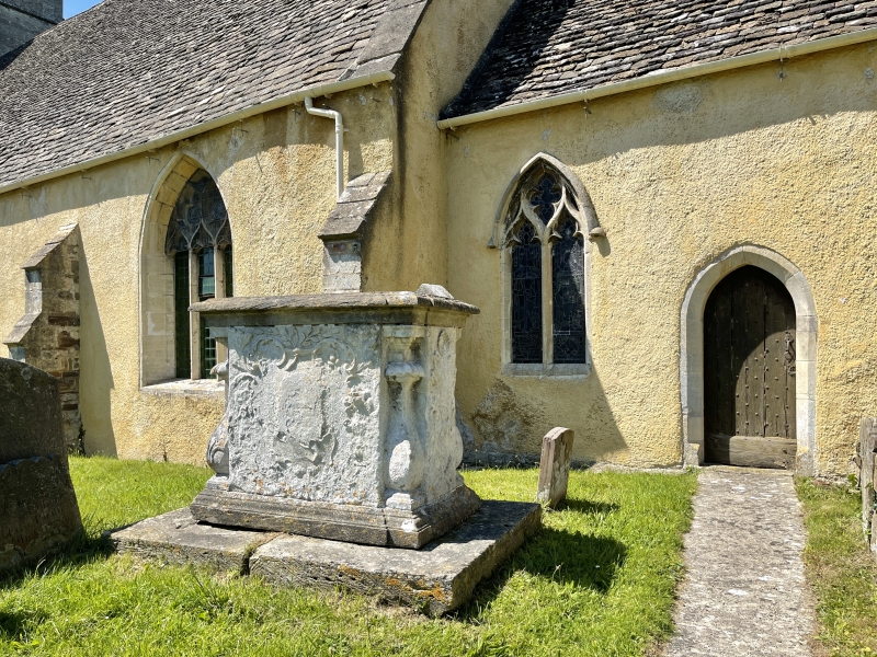
2/11 Unidentified Monument, about 4m
south-west of priest's door in
churchyard of Church of St. Mary
GV II
Tall chest tomb. Mid C18. Limestone. Flat top with moulded
plinth and capping on large base. Gadrooned quarter balusters,
with cartouche and shell to east, urn to west, raised circle with
low relief surround to north, and much eroded high relief bellied
cartouche to south. Inscriptions obliterated.
Listing NGR: SO7066810664
External links are from the relevant listing authority and, where applicable, Wikidata. Wikidata IDs may be related buildings as well as this specific building. If you want to add or update a link, you will need to do so by editing the Wikidata entry.


Other nearby listed buildings
