Latitude: 50.7899 / 50°47'23"N
Longitude: -2.1245 / 2°7'28"W
OS Eastings: 391317
OS Northings: 98934
OS Grid: SY913989
Mapcode National: GBR 209.HNW
Mapcode Global: FRA 67F0.44C
Plus Code: 9C2VQVQG+X5
Entry Name: Church of St Mary
Listing Date: 18 March 1955
Grade: I
Source: Historic England
Source ID: 1154550
English Heritage Legacy ID: 107675
Also known as: St Mary's Church, Almer
ID on this website: 101154550
Location: St Mary's Church, Almer, Dorset, DT11
County: Dorset
Civil Parish: Sturminster Marshall
Traditional County: Dorset
Lieutenancy Area (Ceremonial County): Dorset
Church of England Parish: Almer and Charborough St Mary
Church of England Diocese: Salisbury
Tagged with: Church building
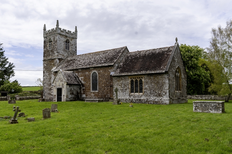
STURMINSTER MARSHALL SY 99 NW ALMER 9/50 Church of St Mary 18.3.55 - I Parish church. C12 nave and north arcade, C14 rebuilding of the north aisle, west tower of C15, south wall of nave and south porch C18 (1720), chancel rebuilt late C19, restoration of 1908. Walls of ironstone rubble (some flintwork) with large quoins, bands of limestone, ironstone ashlar of small (chancel) and large (nave) blocks, with limestone dressings; plinth, eaves moulding to part. Tile roof, with stone slates to the lower courses. The nave south wall has two round-headed windows with a simple architrave and key; the north aisle wall is mainly C14 with three windows (2 of the C14), and the west end shows earlier masonry and the remains of a north door; the chancel has a window to each wall of C14 style. The tower is of two (external) stages, with a crenellated parapet and corner pinnacles, coupled traceried openings to the bell stage, and a lower window on the west face, plinth, weathered band and moulded band below the parapet. The south porch contains a re-set Norman doorway. Inside, the Norman arcade has round arches on cylindrical columns, with scalloped caps and square bases; the tall tower arch has two moulded orders, the Purbeck font (c1400) has an octagonal bowl with coupled arches to each face, supported on a narrow column, which rests on a C13 inverted bowl (itself re-cut). The fittings are 1908, but there is a Royal Coat of Arms of George III, 1800, and a small inscribed brass of 1517. RCHM
Listing NGR: SY9132098931
External links are from the relevant listing authority and, where applicable, Wikidata. Wikidata IDs may be related buildings as well as this specific building. If you want to add or update a link, you will need to do so by editing the Wikidata entry.


Other nearby listed buildings