Latitude: 51.9904 / 51°59'25"N
Longitude: -0.6031 / 0°36'11"W
OS Eastings: 496014
OS Northings: 233365
OS Grid: SP960333
Mapcode National: GBR F2D.4BV
Mapcode Global: VHFQY.H7JG
Plus Code: 9C3XX9RW+5Q
Entry Name: Park Farm Dairy
Listing Date: 16 March 1987
Grade: II
Source: Historic England
Source ID: 1158392
English Heritage Legacy ID: 38284
ID on this website: 101158392
Location: Central Bedfordshire, MK17
County: Central Bedfordshire
Civil Parish: Woburn
Built-Up Area: Woburn
Traditional County: Bedfordshire
Lieutenancy Area (Ceremonial County): Bedfordshire
Church of England Parish: Woburn
Church of England Diocese: St.Albans
Tagged with: Building
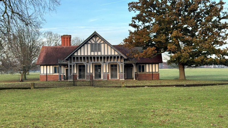
SP 93 SE WOBURN WOBURN PARK
3/188 Park Farm Dairy
GV II
Former Dairy, now a slightly isolated part of the Park Farm complex. Dated
1900, but apparently rebuilding on site of earlier structure (Bedfordshire
Record Office: R Box 818 bundle 18/37, plan of farmstead c.1830). Built for
Herbrand 11th Duke of Bedford. High red brick plinth, applied timber framing
with plaster infill. Ashlar dressings. Clay tile roofs. Symmetrical
single-storeyed cross plan. S elevation: central gabled block is taller than
flanking wings. Gable attic projects over verandah on timber supports, and
shelters 3 pairs of French windows. Attic has 3 openings with louvred
shutters. Flanking wings each have doorway under flat-roofed open porch
adjacent to central gable, and 2-light mullioned window. Porches have
ornamental timber balustrading to roofs. Other elevations have large mullion
and transom windows. Side wings have tall slightly projecting brick chimney
stacks to N elevation, both with ornamental moulded shafts. Gables have deep
verges with plain bargeboards and moulded drop finials. Dairy stands in
ornamental octagonal site bounded by ha-ha.
Listing NGR: SP9601433365
External links are from the relevant listing authority and, where applicable, Wikidata. Wikidata IDs may be related buildings as well as this specific building. If you want to add or update a link, you will need to do so by editing the Wikidata entry.


Other nearby listed buildings